


Dr. Bryan Cole
The agency’s director of its Uncrewed Systems Research Transition Office explains the growing importance of UASs in its work. Peter Donaldson reports
With scientists for parents, a biology teacher uncle and a childhood spent largely outdoors, environmental science called to Dr Bryan Cole from an early age. These days, he heads the Uncrewed Systems Research Transition Office (UxSTRO) at the US National Oceanic and Atmospheric Administration (NOAA), where his remit is to explore how uncrewed systems of all kinds can help further NOAA’s mission to monitor, understand and predict the global environment.
“What drew me to NOAA was that it is an applied environmental science agency,” he says. “It has a wonderful mission: it studies, monitors and manages the United States’ oceans and coasts, forecasts the weather and works to understand and forecast the climate as well as managing marine fisheries and endangered marine species.”
Climate change and the blue economy
Climate change is also central to this mission. “A major focus of the agency, is understanding our impact on the climate and forecasting what is going to happen in a wide range of scenarios,” he says. “Studying that is part of the global community.”
NOAA is also tasked with supporting the growth of the blue economy, a term that refers to the exploitation, preservation and regeneration of the marine environment. “We’re working to develop our understanding and grow industry in the maritime technical space,” he says.
“NOAA really has a wide range of missions, and there are many ways in which uncrewed systems can be applied to them, from the top of the atmosphere to the bottom of the ocean, with the goal of filling gaps in observational data.”
He explains that if anybody in NOAA wants to find out whether any kind of uncrewed system can gather information that they couldn’t otherwise get, the UxSTRO works to help them.
Connections and synergies
Rather than developing its own uncrewed systems, NOAA works primarily with the private sector, he says, so that when someone in the administration comes to him with a mission to sample the top of the atmosphere, for example, and thinks they can do it with an uncrewed system, he can connect them with companies and academic institutions that can help.
“We work very closely with industry to keep up to speed on the latest developments and help people in NOAA become aware of new capabilities coming along, and to see if there is a way to apply them to their missions.”
An important part of this is looking for overlaps and potential synergies between different projects. “Say two people in the agency are both using UASs to take images, with one interested in studying sea turtles and the other in assessing the damage from tornadoes or other severe events,” he says.
“They might not know there’s an overlap in what they’re doing, even though they’re both thinking of ways to increase their capability to use the information, so bringing those groups together and seeking ways to foster greater capabilities through collaboration within and outside the agency is crucial.
“We support many partnerships with people across the agency, and through cooperative r&d agreements the government can partner with companies to test out things they’re developing that might work for our purposes. That helps spur their development and application in the government.”
Dr Cole leads a team of four at the UxSTRO to support project management through acquisitions, contracting, science, r&d, selecting projects to fund and going through the funding process, he explains.
He characterises the process of choosing which projects to fund as very formal, with subject matter experts reviewing all the proposals and ranking them based on established criteria. Next, a smaller team goes over the written reviews to assess which best match high-priority NOAA missions, with a final expert review then ranking those left according to which are most likely to produce useful results.
Atmospheric sampling
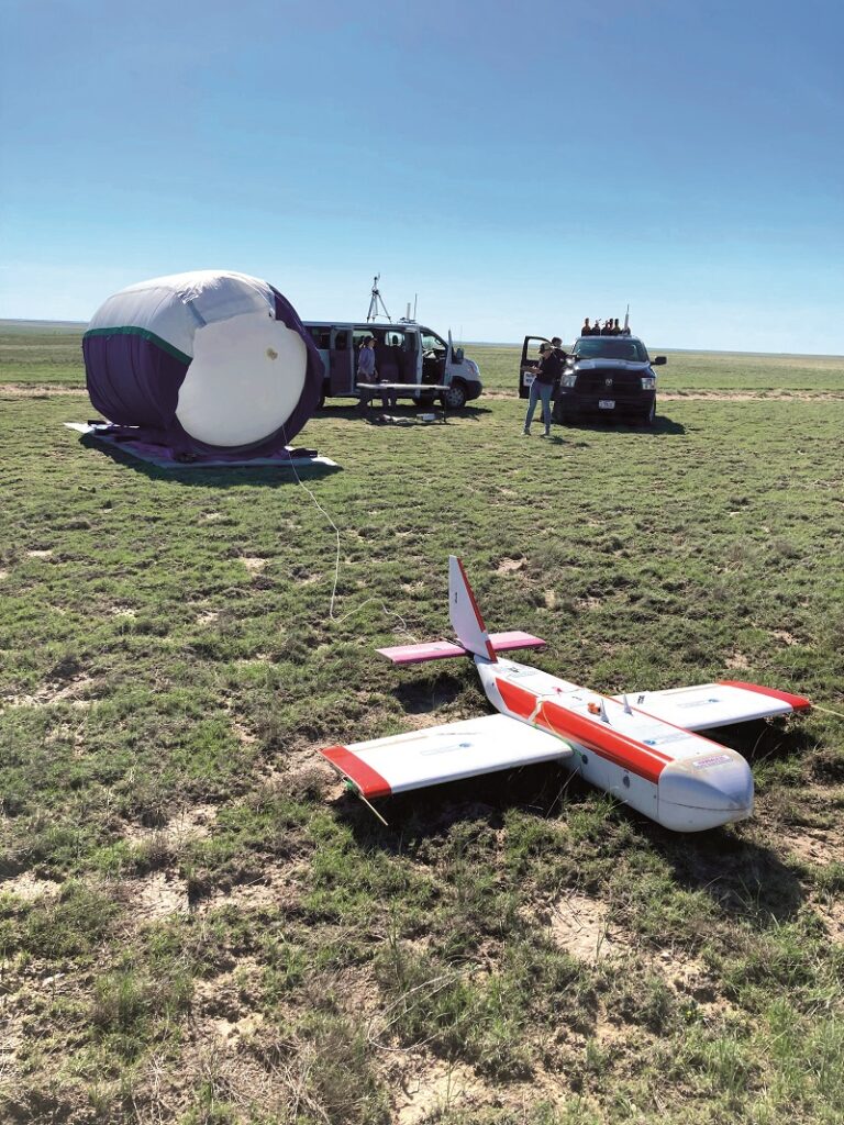
At the moment, NOAA is supporting projects such as the High-altitude Operational Returning Unmanned System (Horus) atmospheric sample collection glider. Horus is a new element of an ongoing multi-phase project run from the Global Monitoring Lab in Colorado, whose mission is to study and monitor greenhouse gases in the atmosphere over the long term, right up to the top of the atmosphere.
“It’s really hard to get to the top of the atmosphere and take a sample, because it’s 95,000 ft up – practically in space,” Dr Cole says.
The lab has developed a device called the AirCore atmospheric sampling system for a weather balloon to carry to the top of the atmosphere before bursting, releasing the device to descend under a parachute and take its sample. While the parachute reliably brings the AirCore down safely, where it lands is dictated by the winds during its descent, which can deposit it up to 100 miles from the launch point.
The Horus was developed to solve that recovery problem, carrying two AirCores internally, spiralling down under autopilot control and landing as near to the chosen spot as possible. The system completed its first mission with a full scientific payload in May this year.
Sample return is critical to data quality. “There are lightweight sensors that can take in-situ measurements of the chemicals the lab is interested in, but not at the high level of precision this kind of monitoring requires,” Dr Cole explains.
He compares the process with that of drilling ice cores from glaciers, which preserve a record of the atmosphere’s composition stretching back thousands of years. “We can’t freeze and preserve the gases themselves, but we have very high quality measurements. The instrument the lab uses detects molecules at a sensitivity of the order of parts per trillion, or one out of every 1012 molecules in the sample.”
Dr Cole says there is interest in expanding the Horus system to more sites in the US, from other countries and at sea where such observations are particularly scarce, potentially even forming a global network. “That would be very powerful in building our understanding of the composition of the atmosphere and its change over time,” he says.
Another key atmospheric region for getting more and better information to improve forecasting is the planetary boundary layer, which extends from the surface up to an altitude of between 3000 and 10,000 ft, Dr Cole says. This is where most of our weather is, and it is the subject of the 2-hourly forecasts on which aviation relies, and which in turn rely on aviation.
He explains, “In NOAA we have a partnership with commercial airlines to put weather sensors on their aircraft, because as they take off and land, they fly through that boundary layer. But they are limited in time and place. Where there are big, active airports we get a lot of observations; in other places we get fewer.”
To address this, NOAA’s National Severe Storms Laboratory is running the Progressive Research and Optimization of a Durable and Independent Generation of UAS (Prodigee-UAS) project with UxSTRO support. The idea is to develop a family of robust VTOL UASs that can be integrated with existing weather monitoring networks such as mesonets – US mesonets constitute a distributed, land-based weather observation system of sensor arrays in a regular pattern.
“Incorporating UASs into that is a way to turn a two-dimensional monitoring into a 3D system.”
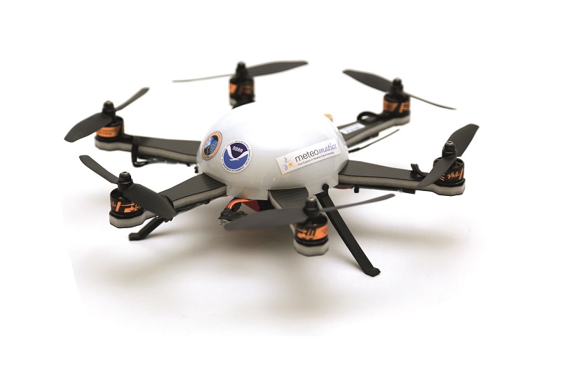
The UxSTRO is already supporting several projects seeking to integrate UASs into existing monitoring systems. Prodigee is focused on the CopterSonde, a 2.36 kg quadcopter developed at the University of Oklahoma’s Center for Autonomous Sensing and Sampling in partnership with NOAA, which the team is looking to integrate into the Oklahoma mesonet.
Another is an Oklahoma State University (a separate institution) collaboration with NOAA’s National Weather Service Tulsa Weather Forecast Office to integrate data collected by a Meteomatics Meteodrone into the office’s 6-hourly regional forecasts.
Probing hurricanes
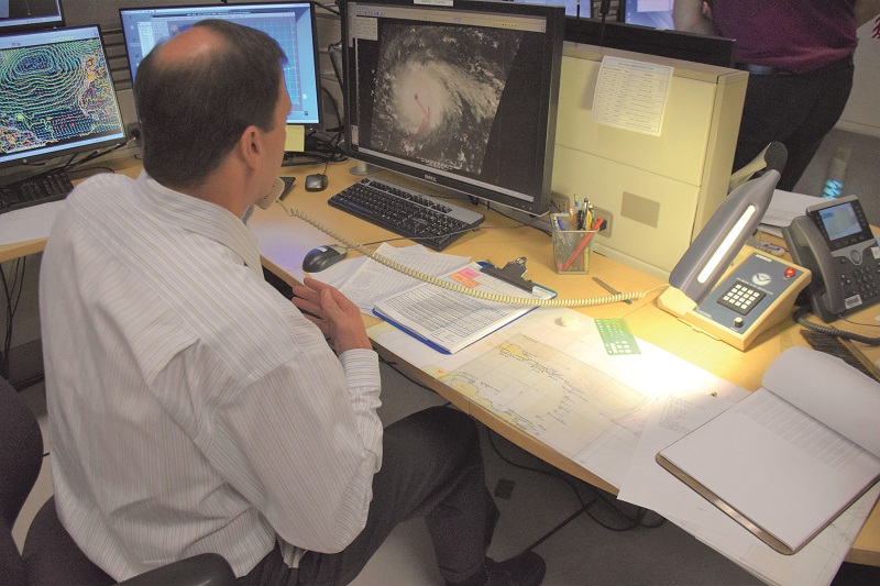
NOAA also monitors hurricanes. “Understanding and being able to forecast where those storms are heading, and how intense they’re going to be when they make landfall, is critical,” Dr Cole says.
“NOAA, along with the US Air Force and other services, fly hurricane hunter missions in which scientists get on planes and fly through the eye wall of a hurricane.”
Minimising the need to put people in harm’s way is a classic use of uncrewed systems, and NOAA is running a series of r&d projects with the Atlantic Oceanographic and Meteorological Lab in Florida and the Pacific Marine Environmental Laboratory in Washington state to deploy uncrewed systems into the storms and provide unique observations in real time to forecasters at the National Weather Service.
Cole points out that satellites can only see the surface of the ocean, so if a mass of very warm water is concealed by a cold freshwater ‘lens’ above it, the satellite will only see the cold water. If a hurricane stirs it up, the heat energy is transferred into it and causes rapid intensification of the storm.
“If it happens near a land-falling hurricane it can increase the storm from Category 3 to 5, for example, just because of the hot water. Historically, that has been very difficult to forecast.”
Buoyancy-driven underwater gliders are already being deployed in the Atlantic to collect detailed information over wide areas and large depth ranges to build an understanding of the ocean’s heat content. In recent years, NOAA has partnered with Saildrone to use a platform designed to withstand hurricanes and collect storm data at the surface.
NOAA has also developed aircraft-launched UAVs and is working to deploy them into storms. In June 2022, as Hurricane Ian made landfall in Florida, it launched a small Altius 600 from the WP-3D Orion Hurricane Hunter aircraft into the storm, Dr Cole recalls.
“It flew around inside Hurricane Ian for about 100 minutes and measured wind speeds faster than the airspeed of the platform itself, which meant it was essentially flying backwards in the storm, as low as 500 ft off the surface of the ocean,” he says. “That information was piped directly to the forecasters at the Hurricane Center, and they were able to verify wind speeds and directions, and provide better information to emergency managers about the severity and likely impact of the storm.”
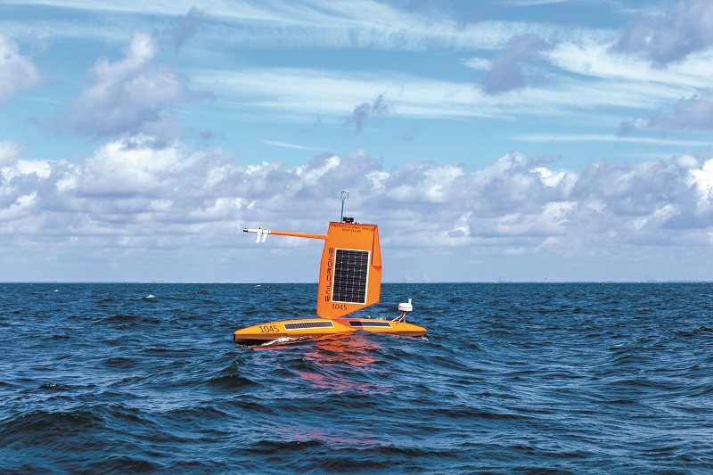
Climate monitoring with Saildrones
“We have a mission to send Saildrones to the eastern Tropical Pacific Ocean,” he says. “The sea’s temperature in that region is what determines El Nino or La Nina, which have a major impact on our climate. But it’s in the middle of the Pacific Ocean, a long way from everything, so we use robotic sailboats that can stay out for a very long time doing targeted missions to observe and understand the ocean and the atmosphere in those regions.”
After a year in the job, Dr Cole now wants to grow the programme. “The potential to apply uncrewed systems to what NOAA is doing is huge, and will bring about their global use as well. I’m keen to explore anything we can do to grow our understanding of the atmosphere and the ocean, and share our knowledge with other parts of the US and other governments.”

Dr Bryan Cole
Born in 1980 in Texas, Dr Bryan Cole grew up in the Midwest and developed an interest in nature and science at an early age.
He earned bachelor’s degrees in biology and chemistry at St Olaf College in Minnesota, where his uncle and mentor Eric Cole teaches biology. “The first thing about him that comes to mind is the passion and joy he has in being outside and studying the environment. He’s constantly observing and learning, and has a very deep naturalist philosophy,” he says.
A PhD in biological sciences from Stanford University followed, during which he spent most of his time at the institution’s Hopkins Marine Station in California, studying developmental biology and toxicology in sea urchins. Postdoctoral work took him to the University of California, Davis, where he developed chemical assays for gauging the impacts of novel contaminants including engineered nanoparticles.
His introduction to NOAA came after this postdoctoral work, when he served on the staff of the US House of Representatives supporting the development of ocean policy. That was followed by a job at the US Geological Survey and then NOAA.
At NOAA, his focus is on understanding everything the organisation is doing and communicating it to Congress, which has given him what he calls ‘the 60,000 ft view’. “When I started working on this programme in 2020, I found that understanding what everyone was doing helped me support their work,” he says.
UPCOMING EVENTS


