


Intergeo 2022


Spatial interest group
Outdoing its pre-pandemic popularity, this year’s geospatial survey and mapping show had plenty of highlights, as Rory Jackson reports
The wave of technology exhibitions returning to the international stage continues, with Intergeo 2022 having taken place in the German city of Essen for its latest iteration. This geospatial survey and mapping show featured 457 exhibitors from more than 30 countries, as well as around 14,000 trade visitors from more than 100 countries, surpassing its figures from before the Covid pandemic.
Companies eager to showcase results from their past few years of r&d filled the halls to reveal new products and solutions across navigation, imaging, processing and particularly uncrewed systems, with a selection of these exhibits discussed here.
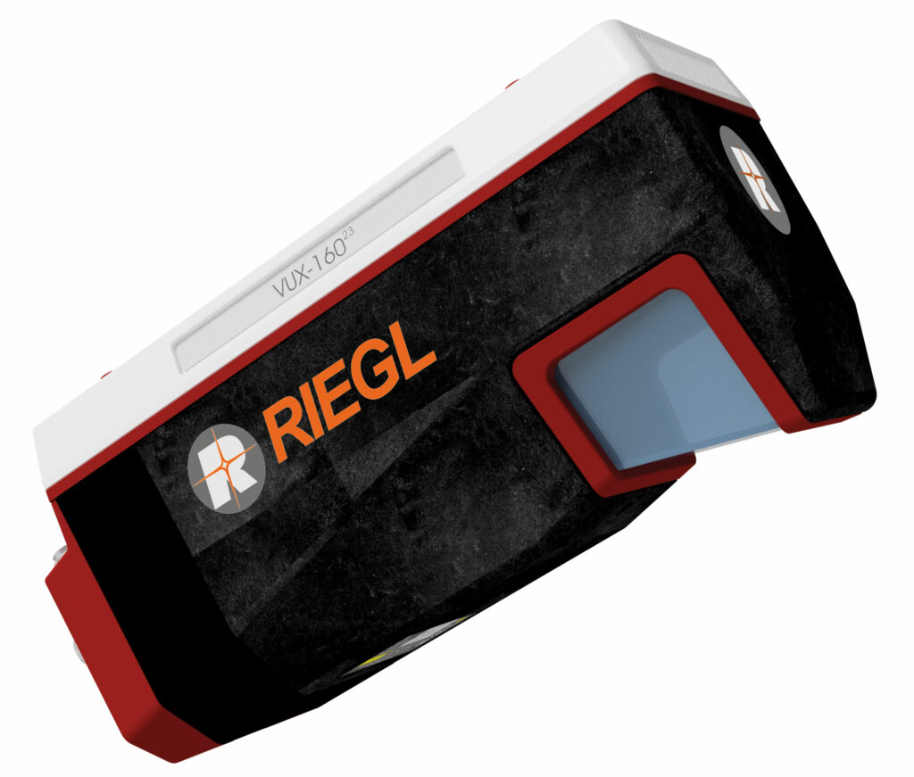
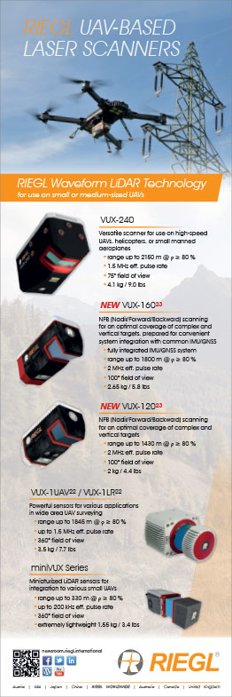
Riegl unveiled its VUX-16023 Lidar, a larger version of the VUX-120 sensor it released at Intergeo 2020. The company also updated its VUX-120 system, renaming it the VUX-120²³, which included raising its maximum pulse repetition rate to 2.4 MHz from the previous model’s 1.8 MHz.
“What’s unique about the VUX-160²³ – as well as the VUX-120²³ – is that it has a very innovative scan pattern,” explained My-Linh Truong. “Most airborne laser scanning sensors have a rotating mirror design, with a matrix scan pattern on the ground looking towards their nadir. However, these Lidars use what we call NFB, or Nadir/Forward/Backward scanning – one nadir-pointing perspective, one canted forwards 10º and one canted backwards 10º.
“That gives three perspectives per flight pass, providing much more complete coverage than is typical of most airborne laser scanners, even in complex applications such as deep canyon terrain mapping or 3D modelling of vertical structures like powerlines.”
She added that the VUX-160²³ offers a maximum pulse repetition rate of 2.4 MHz, a 100º FoV, and an operating ceiling of 900 m AGL, enabling its use over a wide range of terrains and altitudes, while weighing 2.65 kg to suit the payload capacity of various UAVs.
“For precise georeferencing of our laser scan data, we continue to integrate Applanix IMUs with Applanix’s new AP+ Series IMU/GNSS; depending on customer selection, the board stack for either the AP+30 or the AP+50 models are built inside the VUX-160²³,” Truong said. “The VUX-160²³ also supports the integration of up to five cameras for mapping and surveying to achieve additional data gathering, fusion and analysis.”
Both Lidars are now commercially available and first deliveries are targeted for 2023.
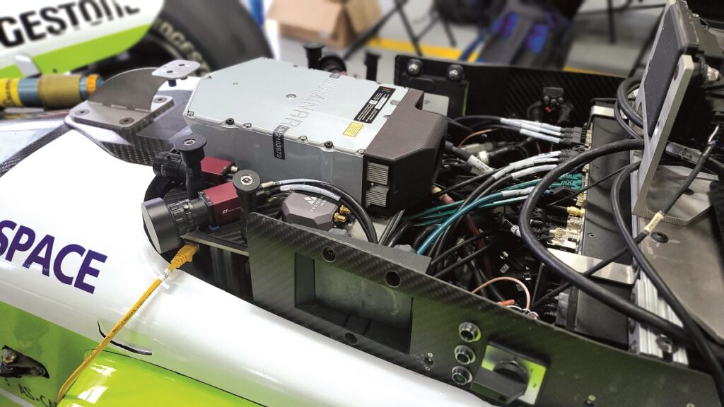
VectorNav Technologies is continuing to collaborate with the Indy Autonomous Challenge through supply of its VN-310 dual antenna GNSS INS to the AV-21 autonomous racecar (as featured in UST 46, October/November 2022).
(below the Luminar Lidar box)
“Our system provides the team’s self-driving racecars with precision RTK-GNSS as they drive around the racetracks, and we’ll be working with the teams in a technical capacity during their next race event at the Texas Motor Speedway,” said Jeremy Davis.
“Aerospace and racing have similar environmental considerations as far as INS environments and capabilities are concerned,” he added. “We’ve done a lot of UAV applications in the past that had high-speed launches which were comparable to the kinds of speeds, forces and NVH that the AV-21 cars go through.
“And our Industrial series of products have gone through even more use cases of a high-speed, high-dynamics nature. For instance, the VN-300 has been used for telemetry in the Red Bull Air Race.”
The 160 g VN-310 provides dynamic heading readings accurate to 0.05-0.1º, with less than 10 µg of accelerometer in-run bias and less than 1º/hour of gyroscope in-run bias. Navigation data is output for the racecars at 400 Hz, with IMU data transmitting at 800 Hz.
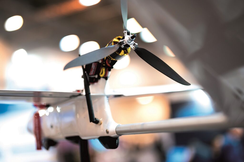
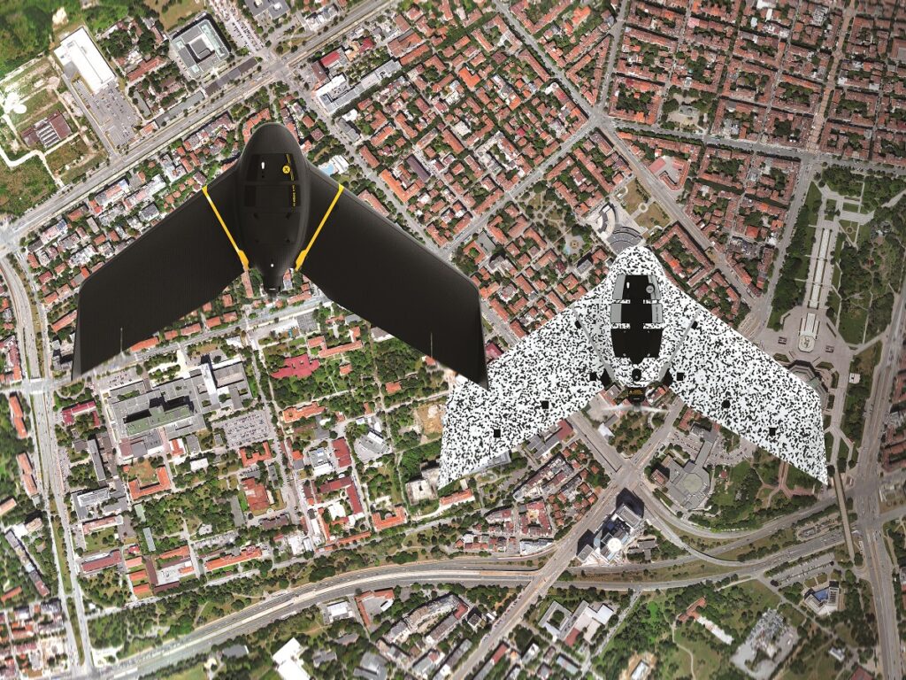
ElevonX attended Intergeo to show that it had progressed its plans to make a larger version of its Sierra VTOL UAV, called the Tango (see UST 42, February/March 2022), with a mock-up of the 19 kg MTOW craft at its stand.
“The Tango is now in production and is being beta-tested with AIRlabs Austria, who are trialling it with their own sensors, infrastructure and equipment to see how different customers could use it,” said Matej Meglic.
“Notably, this VTOL-transitioning UAV can land on water,” he added. “We were approached by the Slovenian Navy because its ships sometimes need to move to different locations before their UAVs have returned, so the Tango can land and wait for at least 3 hours to be picked up.”
When landing on water, the survey payload is retracted inside a watertight chamber. The chamber measures 45 x 23 x 23 cm to enable large UAV gimbals to be integrated.
Also, the T-Motor lift and pusher propulsion motors installed about the Tango’s booms and rear are IP-rated to withstand being submerged in water, and a sealing agent is applied between all the hull joints to prevent water ingress there.
The Tango has a 3 m wingspan and a top airspeed of 125 kph. Its endurance is 2.5 hours when configured for fully electric, battery-powered flight, although it can also be equipped for gasoline-hybrid flight to extend its flight time to 6 hours. Hydrogen fuel cells can also be installed, with tests of hydrogen-electric flight planned for the future.
SBG Systems showcased its Quanta Micro board, its new MEMS-based INS developed as a highly SWaP- and cost-optimised solution capable of providing direct georeferencing in UAV and land-based surveying missions.
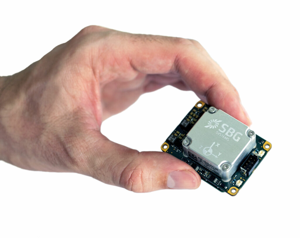
“The Quanta Micro is a high-performance GNSS-aided INS that integrates our tactical-grade Pulse-40 IMU, an onboard 8 Gbyte data logger, web interfaces supporting NTRIP, FTP and NTP/PTP, and external connectivity through Ethernet, UART, CAN bus, odometer and DLV,” said Dr Ryan Keenan.
The Quanta Micro INS measures 50 x 37 x 23 mm and weighs 38 g, consuming up to 1.1 W in normal operation. Roll and pitch are outputted at an accuracy of up to 0.03°, or 0.02º if RTK processing is used (and 0.015º is achievable with PPK).
Dr Keenan also discussed SBG’s Qinertia PPK software, noting that the solution allows for end-users to specify what kind of vehicular motion a data acquisition campaign was collected under.
“That includes selecting the motion profiles from a detailed list of various automotive, airborne and marine craft, so the software’s extended Kalman filter understands what kinds of movement-based errors to recognise and then tunes the sensor fusion algorithms to provide the optimal behaviour of the INS,” he said.
Phase One exhibited its range of high-end aerial imaging solutions for different UAV and piloted aircraft integrators, with two solutions proving particularly interesting to the show’s attendees.
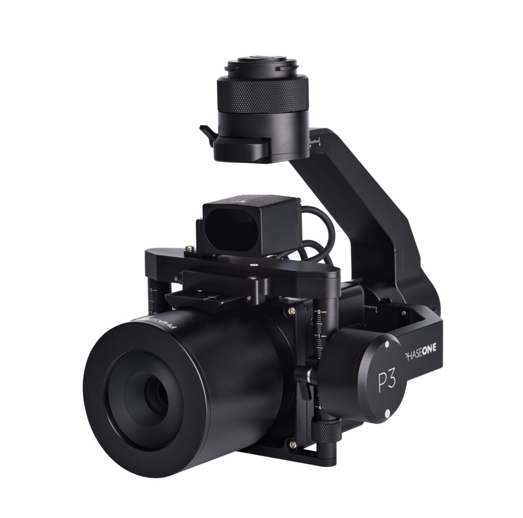
Of the two, the smaller is the P3 payload, a three-axis gyro-stabilised system for plug-and-play integration of Phase One’s iXM100 cameras with small UAVs. The cameras provide 100 MP imagery for high-resolution inspection and mapping missions, and the P3 weighs about 2.6 kg.
“The P3 camera-gimbal combination consistently captures sub-millimetre images of the most complex structures such as high-voltage power structures, wind turbines, dams and bridges,” said Robert Bosch.
The gimbal can interface over MAVLink, DJI and Auterion protocols for integration with a range of UAV platforms and autopilots. The lenses are interchangeable from 35 mm to 150 mm depending on the level of detail needed for a given job.
Phase One also showcased its PAS 880i, an oblique aerial mapping system that integrates seven Phase One iXM150 cameras disposed to capture both nadir and oblique perspectives – two nadir-pointing RGB cameras, one nadir NIR camera, and four oblique RBG cameras.
“Our cameras combine ultra-high shutter speeds of up to 1/2500 second with highly sensitive CMOS sensors, which captures images at such a fast speed that it compensates effectively for motion blur, so we call it our Blur Control Technology or BCT,” Bosch said. “Other cameras need complex mechanical or algorithmic solutions, but with our cameras designed using BCT, we don’t need that.”
Tyker attended the exhibition to show its Robot Plotter UGV, a solution for autonomous line marking, drilling and other tasks in construction and roadworks jobs.
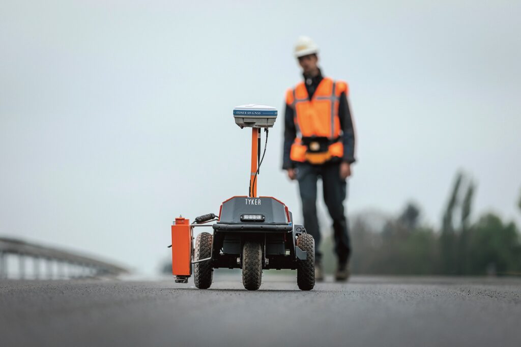
Xander Zaaiman said, “Accurate line marking and hole drilling are of critical help to road construction or building sites, and our system can work with base measurements from GNSS or a total station EO tool to maintain such accuracy. We also have some modifications we can make to the robot to perform surveys, either before it does a construction job in order to pre-program its waypoints, or afterwards to evaluate how well it did.”
The company’s own software is tailored to fuse GNSS, EO and IMU data, and to control the autonomous movements of the Robot Plotter in a way that ensures lines come out smoothly (smoothness being slightly more important to road construction customers than accuracy), accounting for differences in the navigation inputs measured and where the output of the line-painting payload will result.
We talked to Outsight about its Lidar real-time processing software, which among other features has a SLAM capability that makes navigation and perception easier for autonomous systems.
“We take raw data from many 3D Lidar models, such as those from Hesai, Ouster, Velodyne and Robosense as input and pre-process it to provide developers with actionable data by applying our SLAM algorithms,” explained Neder Malouche.
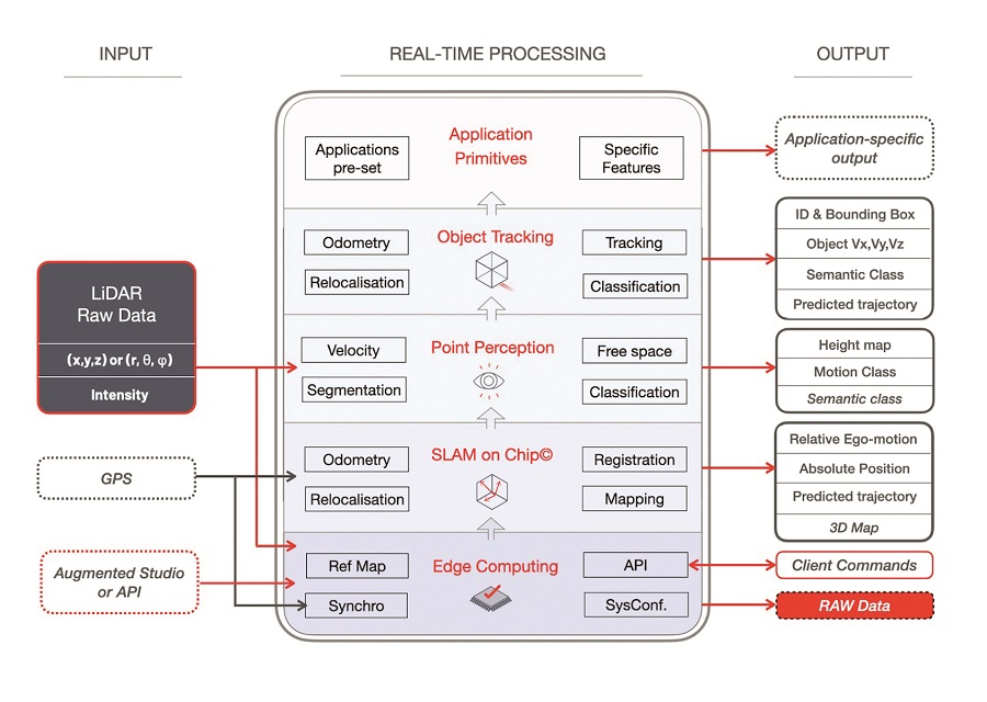
“The algorithms can then apply functional intelligence depending on whether the mobile autonomous system is in an unknown environment – and hence needs to construct an all-new 3D map of its surroundings and keep localising itself within that map – or if it’s in a known place and needs to recognise its whereabouts in that place according to a pre-existing reference map.”
Outsight’s software also contains features for point perception, super-resolution, and object tracking and classification that enable safe real-time 3D SLAM-associated applications for a variety of road and off-road smart vehicles.
“Our software can recognise moving objects like pedestrians, two-wheelers and trucks as well as static objects like traffic lights and stop signs,” said Malouche.
“All our algorithms are rule-based; we don’t rely on complex AI, so any processing unit using our technology won’t consume too much power.”
The company embeds its software in its Augmented Lidar Box as a starter kit for developers who choose not to develop or acquire their own processing capabilities. It also provides its software in a post-processing capacity unit for users gathering Lidar data for maps and surveys.
AgEagle attended the expo to show its range of UAV, software and payload solutions for data acquisition, fleet management and post-processing, in particular its eBee X and eBee TAC UAVs for quick mapping and surveying with single operators.
“MicaSense, senseFly and Measure have been acquired and combined under AgEagle to provide a full-stack uncrewed aerial survey capability for geospatial, mining, agriculture, humanitarian and similar missions,” explained Christopher Thomson.
The eBee X is a fixed-wing UAV designed for large-area mapping. The company noted that it is currently approved for BVLOS operations in Brazil and Operations Over People (OOP) in Canada and the US, and is also the first UAV to be C2-certified and to have obtained a design verification essential for BVLOS and OOP in Europe.
It has a wingspan of 116 cm, a MTOW of 1.6 kg, and a maximum airspeed of 110 kph. As standard, it comes with a 37 Ah battery, with which it can cover 220 ha of survey area, although a 49 Ah pack is also available to extend its mission coverage to 500 ha.
“A camouflaged version of the eBee X, the NDAA eBee TAC, has enhanced software security upgrades designed according to the requests of the US military to gain their approval,” Thomson added.
In March 2022, the eBee TAC was approved for use by the US Department of Defense under the Blue UAS Cleared List.
We also caught up with Silicon Sensing to discuss its DMU41 IMU, which is currently going through its final stages of qualification testing before entering production.
“The DMU41 is our newest high-performance IMU, and will be tested in line with the DO160G standard,” said Katie Howard.
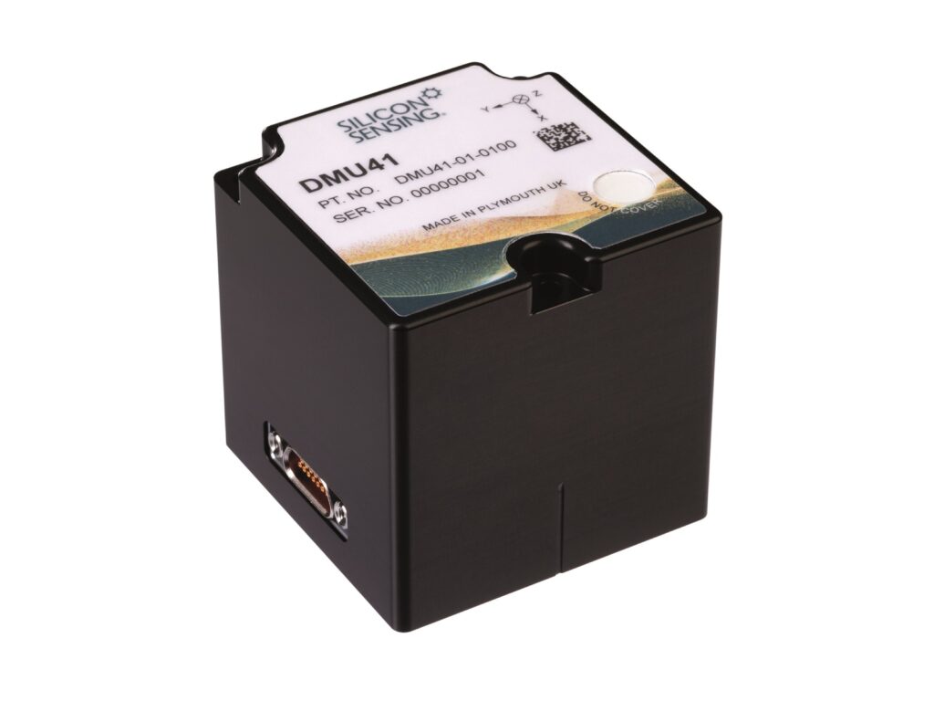
Weighing just under 170 g, it consumes up to 2.5 W and measures about 50 x 50 x 50 mm.
It uses three inductive and three piezoelectric resonating ring gyroscopes to output measurements with a dynamic range of ±490º/s, a bias over temperature of ±7º/hour and a bias instabilitywithin 0.1º/s. The accelerometer has a dynamic range of ±10 g, a bias over temperature of ±1.7 mg, and bias instability of within 0.015 mg.
Advanced Navigation showcased its new Boreas D70 FOG-based GNSS INS. As Romain Pare told us, “Last year, we launched the Boreas D90, the world’s first digital FOG INS, which offered gyro-compassing and a level of performance way ahead of anything else in this price range.
“That in turn created a gap between our Spatial FOG Dual, which is a traditional GNSS-aided FOG, and the Boreas range; the D70 fills that gap. It has the D90’s SWaP, and can still do the north-seeking gyro-compassing that the D90 does, but it is far less expensive, with the caveat of having slightly lower performance.
“We specifically made it for clients who said they didn’t require as much accuracy but very much needed to save development costs, and keep on functioning robustly in GNSS-denied environments such as mining, offshore and some defence applications.”
The D70 is a 2.5 kg unit measuring 160 x 140 x 115.5 mm. It integrates the Advanced Navigation Aries GNSS receiver with GPS L1 and L2, GLONASS L1 and L2, Galileo E1 and E5b, and BeiDou B1 and B2, as well as the WAAS, EGNOS, GAGAN and QZSS SBAS aiding services. It has an update rate of up to 20 Hz, a timing accuracy of 20 ns, velocity accuracy of 0.05 m/s and unaided horizontal position accuracy of 1.2 m (0.5 m with SBAS; 1 cm with RTK).
Its gyroscope has a range of ±490º/s, a bias instability within 0.01º/hour, an initial bias within 0.05º/hour, and an angular random walk of less than 0.005º/√hour. Its accelerometer meanwhile has a range of ±15 g, less than 7 µg bias instability, within 100 µg initial bias, and less than 23 mm/s/√hour of velocity random walk.
With dual GNSS, the D70 outputs headings accurate to 0.01º, while also giving pitch and roll to 0.01º, and heave to 2% or 0.02 m (whichever value is greater), all at a rate of up to 1000 Hz.
Maxon showcased its latest electric motors optimised for low-SWaP, cost-effective and robust propulsion on uncrewed aircraft. Of particular note was its ECX 32 UAV flat motor, which is 32 mm in diameter, 18.5 mm tall and 47.9 g in weight, while producing up to 1 kg of thrust force (or 105 W of power output) continuously.
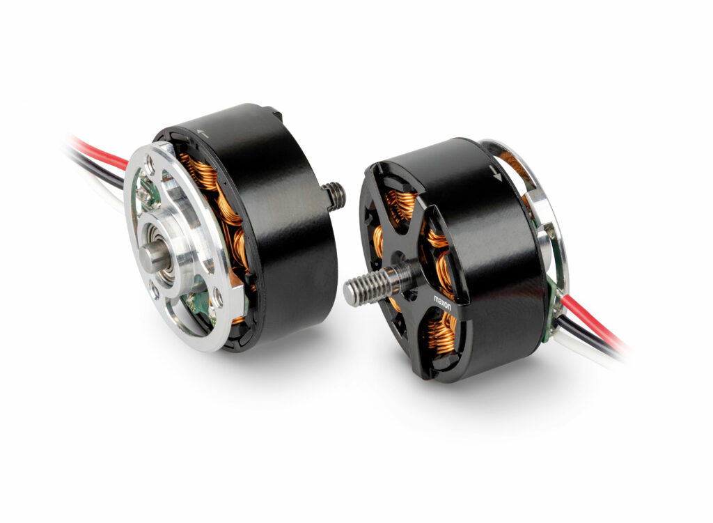
“Developing the ECX 32 was based closely on a proven design from our newest industrial flat motors, whose base technology has had around 20 years of use,” said Marco Sicher.
“With sufficient simulation based on pre-existing data, we were able to strip down weight, increase performance and even make it run as a sensorless device – since most industrial motors use encoders or Hall effect sensors to operate – but we’re still able to produce the ECX 32s with our existing manufacturing lines, and validate their reliability in our existing quality control and testing facilities.”
Maxon also plans to bring out two more sizes of electric motor in the next few months. One, the ECX 42, will be 42 mm in diameter; the other will be smaller, at 22 mm across, with both designs being based on the ECX 32’s architecture.
“These new motors extend Maxon’s UAV propulsion motor portfolio further, and bigger motors are available as well – specifically our EC69 and EC87 flat UAV motors,” Sicher added.
YellowScan spoke with us about its new Voyager solution, its latest product and one that integrates the Riegl VUX-120.
“The Voyager is intended for integration on UAVs and light piloted aircraft, with customers in need of not only precision but also cost efficiency, high survey altitudes, and wide survey ranges, all with a high-density point cloud,” explained Morgane Selve.
It weighs 3.5 kg, excluding battery, and is capable of recording 1.5 million points per second over a 100º FOV (with up to 15 echoes per shot), each measurement having a 0.5 cm precision and 1 cm accuracy. Meant for UAVs as well as light crewed aircraft, the Voyager has a maximum operating altitude of 440 m AGL.
Its users can choose to integrate either the APX-20 UAV or AP+ 50 Air from Applanix as a GNSS inertial board, and it can be powered using its own battery for up to an hour, or the operator can provide external power for the 55 W it requires through the Fischer connector for longer operations. Applanix POSPac UAV/MMS and YellowScan CloudStation software help facilitate post-processing, visualisation and analysis of gathered point cloud data.
Tallysman presented three new GNSS antenna products it said are key to accurate mapping and survey missions.
First was the IP67-housed SSL990XF, which uses a derivative of Tallysman’s patented VeroStar antenna element to provide full frequency coverage of available GNSS and L-band correction services.
The SSL990XF is 63 mm in diameter and 28 mm tall, while weighing 50 g. It has an average phase centre variation of 4 mm or lower for all frequencies and overall azimuths and elevation angles. It supports GPS/QZSS L1/L2/L5, QZSS L6, GLONASS G1/G2/G3, Galileo E1/E5ab/E6 and BeiDou B1/B2ab/B3. Also supported are SBAS including WAAS for North America, EGNOS in Europe, MSAS in Japan, and GAGAN in India.
Next, the AJ977XF triple-band antenna features anti-jam technology by way of a stacked antenna phased array.
“That creates a null [deaf] pattern in the antenna’s radiation for all azimuths and elevation angles ranging between the horizon and about 15º,” explained Julien Hautcoeur. “So the AJ977XF’s element attenuates – with a typically negative gain of -20dB – the in-band and out-of-band GNSS radio spectrum in the aforementioned range.
“The AJ977XF will therefore keep providing a usable GNSS signal in the presence of a ground-based 600 W jammer 100 m or further away.”
Both the SSL990XF and AJ977XF use Tallysman’s eXtended Filtering technology to strongly mitigate out-of-band signals from 500 to 3000 MHz.
Lastly, the TW5390 smart GNSS antenna (from Tallysman division Tallymatics) comes with IP-network and L-band augmentation service capabilities via integration with u-blox’s F9R GNSS receiver and DS9 L-band receiver modules. These enable PPP-RTK corrections in NMEA format over an RS-485 interface to ensure accuracy within 6 cm.
“The TW5390 is ideal for UGVs and some larger UAVs,” Hautcoeur said. “Its GNSS coordinates are corrected through the u-blox PointPerfect augmentation service, via either L-band satellite or IP messages. It also has built-in inertial sensors that provide additional motion corrections to position estimates.”
Exail (previously iXblue) attended Intergeo to showcase a number of its newest products for navigation and georeferencing. Taking centre stage was the UmiX U5 FOG IMU, the company’s first to be size-optimised for navigation applications.
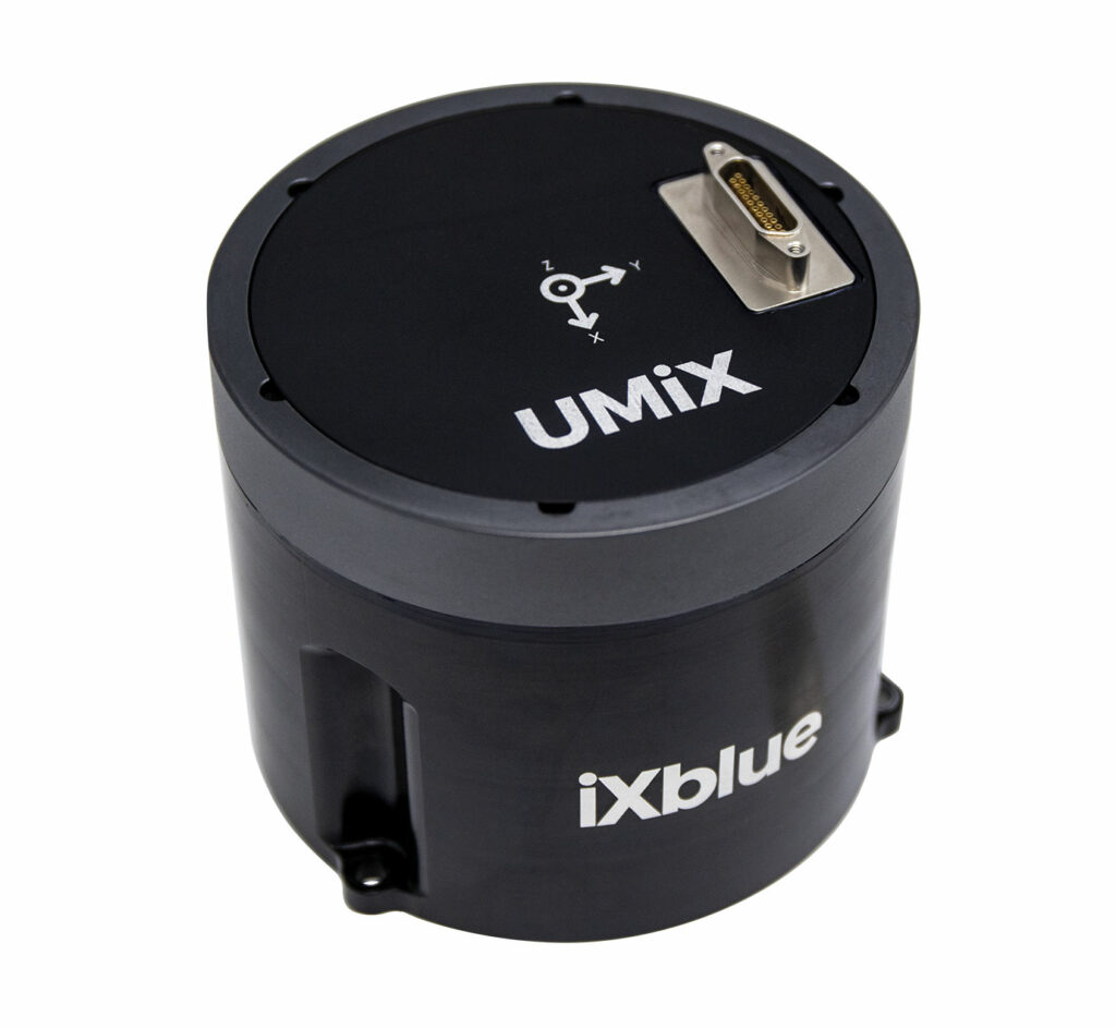
“It’s available for order at the beginning of 2023. It provides rotation and acceleration measurement data at up to 10 kHz, being built on with a miniaturised FOG with new electronics, as well as our new vibrating quartz accelerometers, also made in-house,” said Marie-Lise Duplaquet.
The U5’s FOG operates over a dynamic range of ±490º/s (with its accelerometer’s dynamic range at ±30 g) and has an angular random walk within 0.01º/√hour and a bias repeatability of better than 0.01º/hour.
The IMU weighs just under 770 g, measures 88.9 mm in diameter and is 75 mm tall. It consumes 4 W at ambient temperature (up to 7 W) and interfaces over a 21-pin micro-D rectangular connector as standard, with serial RS-422 ports.

The company also exhibited its Atlans A7, a 2.9 kg INS for land and aerial georeferencing systems that features RTK- and SBAS-enabled corrections for its Septentrio GNSS receiver, as well as its Delph INS post-processing software for fusing and computing mapping data from key land, air, hydrographic and rail navigation products (including geotagging of Lidar and synthetic aperture radar data for detailed 3D maps and models).
Inertial Labs is developing an INS that uses a FOG IMU as an external source to perform gyro-compassing, and hence understanding a vehicle’s true heading.
“It could be used as a pointing device for zero-velocity updates in GNSS-denied environments, where dual-antenna GNSSs can’t get updates,” explained Jamie Marraccini.
“Currently there are no low-cost gyrocompasses available on the market, but with our devices already supporting external aiding data updates, and now direct integrations, we can simply use the gyrocompass directly or indirectly to perform the mission’s required gyro-compassing updates.”
That means for example that a FOG could be placed on a ground installation such as a military turret or a robotic refuelling, or recharging arm station, and a UAV carrying out flights in the area could land, take an update to find north again using the FOG as a reference point, then take off and continue on its mission.
“As well as having engineers who knew how to do this kind of integration, it took time to find a suitable FOG technology in price-performance terms, to be able to offer this new kind of IMU solution,” Marraccini said.
“There are plenty of FOG and RLG IMUs, but this one will fit a certain price model.”
At present, the FOG model used is the IMU-FI-200C, but Inertial Labs plans to spend 4 to 6 weeks testing its own INS with external aiding data from the IMU-FI-200C to verify how accurately the IMU-FI-200C can measure and output true headings without using GNSS.
Based on preliminary test results, the first generation of Inertial Labs’ gyro-compassing system will measure true heading and true north with about 0.5º accuracy.
Pending the successful conclusion of those tests, the gyro-compass will be released as a standalone instrument in February 2023.
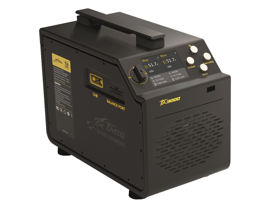
Tattu exhibited its latest battery solutions for manufacturers and operators of electric geospatial survey vehicles, including those in the agricultural sector.
“The new NMC 811 battery is designed with eVTOL fixed-wing aircraft and high energy density in mind,” said Alex Lyu.
“Normal lithium-polymer batteries offer around 200 Wh/kg, but by using the new NMC 811 cathode material, our product delivers 275 Wh/kg, giving more energy and hence flight time relative to mass, as well as lifetimes exceeding 500 cycles if used properly.”
Versions of the NMC 811 battery with 20 and 28 Ah are available; these weigh 1.8 kg and 2.5 kg respectively.
“We also have an NMC 532 module, for high-voltage applications. It is ideal for heavy-duty applications such as agricultural spray drones, or for UAVs carrying really powerful Lidars,” Lyu added.
“They can also be fast-charged at rates of C3 to 5 to keep downtime within 10-20 minutes. The low resistance inherent in their design also really helps with their safety and lifespan in the kinds of hot weather that many agricultural users deal with between March and October, which is when they are needed to be flying the most.”
For easy charging of these batteries, the company also showcased its new TA3000 intelligent charger, which connects to the end-user’s batteries via single discharge cables (without the need for balancing cables) and automatically sets the charging current while accounting for safety margins regarding temperatures and states of health, up to a maximum of 60 A.
“Farmers now make up a huge portion of our business, so this automation is key to making uncrewed systems straightforward for them to use,” Lyu said.
“With this smart 3000 W charger, they don’t need to select a C-rate, they can just choose between a fast mode and a standard mode, and the TA3000 does the rest.”
While Trimble and Applanix products integrated into many systems were shown around the expo, the companies themselves attended to showcase their latest GNSS-inertial sensor fusion solutions, with the new Trimble AP+ Series drawing particular attention.
“We’ve introduced this solution into different vertical markets at different times,” explained Dr Steve Woolven of Applanix. “We launched the AP+ Air first, followed by the AP+ Land variants and finally a Marine variant, but all three use the same core technology, which will be the basis for the next several years of our product development.
“The latest version of our AP+ Series OEM board is designed for every GNSS signal currently available, and it uses Applanix’s latest IN-Fusion+ technology. That takes GNSS signals as well as on- and off-board inertial sensors, Lidar, odometer and camera signals, and fuses it all together into an aided inertial Kalman filter.
“As a result, the AP+ Series can produce highly informed and precise position data for autonomous vehicles in environments such as tunnels and deep-pit mines, or under bridges and forest canopies.”
He added that in addition to strongly aiding autonomous navigation in difficult environments, the AP+ solutions can also be used in gimbals for accurate real-time direct georeferencing and object tracking.
The 100 g AP+ 30 Air consumes up to 7 W and interfaces via a single rectangular Samtec connector for power and data; two MMCX antenna connectors are also installed for calculating heading. It is built using the latest Trimble Maxwell technology with 2 x 336 tracking channels, and the latest Applanix MEMS IMU with the latter’s proprietary SmartCal software for inertial error compensation.
In addition to accessing all available satellite correction services, RTK-processing and Trimble’s RTX-correction services can be used for further signal precision and accuracy.
UPCOMING EVENTS


