


Intergeo 2025

(Image: Intergeo, by Nico Herzog)
Mapping the world
Rory Jackson reports on the latest product launches and advancements at this show intended for geospatial surveyors and engineers using autonomous systems in their critical data-gathering work
Whether mapping agricultural, urban, coastal, mountainous or other terrains, geospatial work is dominated by uncrewed systems. Drones are quicker, cheaper and easier to operate than helicopters, and survey robots on ground and sea are similarly more convenient than their crewed counterparts.
So indispensable are uncrewed systems as survey tools today, that geospatial experts are also increasingly experts on drones and robotic vehicles, avidly researching and seeking-out the latest advancements in survey payloads, avionics, propulsion systems, GNSS, post-processing solutions and more.
All such advancements and more were unveiled at Intergeo 2025 in Frankfurt, which over 18,500 visitors from 119 countries, 530 exhibitors, and Uncrewed Systems Technology were on hand to witness, with a selection of these reported henceforth.
RIEGL launched the new VUX-820-G topo-bathymetric Lidar system – a complete, UAV-ready solution that integrates Lidar, inertial navigation and imaging in a 5.7 kg package.
Although thoroughly SWaP-optimised, the VUX-820-G delivers extensive capabilities over predecessor systems, including depth penetration up to 2.2 Secchi depth, integrated RGB imaging and georeferenced, refraction-corrected point clouds powered by RIEGL’s proprietary software. Also noteworthy is the company’s RiLOC-Finside subsystem – a fully integrated IMU/GNSS solution that eliminates external components, thereby reducing complexity for UAV-based surveys.
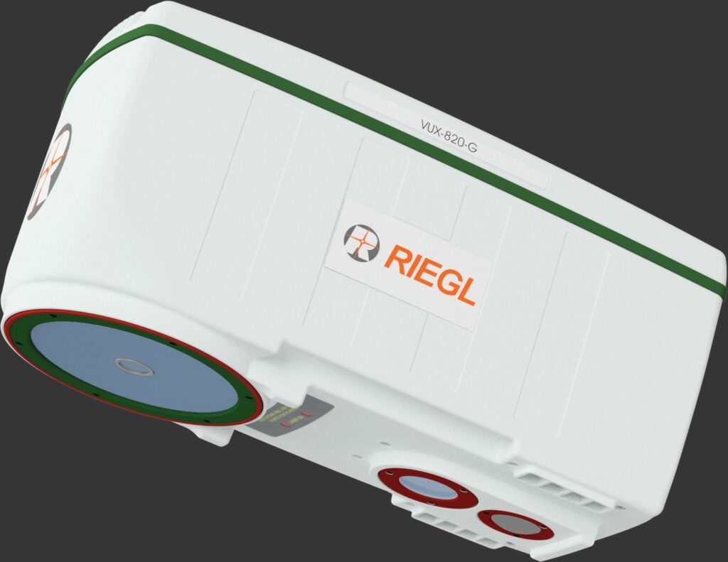
“The VUX-820-G was designed to simplify topo-bathymetric surveying without compromising accuracy,” said My-Linh Truong from RIEGL. “Professionals have long faced challenges with multi-vendor setups, heavy payloads and complex workflows – by integrating Lidar, navigation and imaging into one system, we’re enabling deployment on small UAVs while maintaining precision. This means faster data acquisition, reduced operational costs and the ability to tackle projects in areas that were previously difficult or impossible to survey.”
Additional, practical design features include a built-in display and status LEDs for making field operations easier, while RIEGL’s software ecosystem enables streamlining of the path from data collection to deliverables.
Applications for the VUX-820-G range from coastal mapping and riverbed analysis to infrastructure inspection and environmental monitoring, particularly in hard-to-reach areas.
Norsk Elektro Optikk (NEO) presented its HySpex Mjolnir VS-620, which is a high-end hyperspectral camera integrating two coaligned hyperspectral sensors: one for capturing imagery in the VNIR range and the other for the extended SWIR range.
This means it can cover the full range of 400–2500 nm in one flight, making it a popular choice in the fields of mining, earth observation, urban planning/monitoring and more.
The HySpex Mjolnir VS-620 weighs approximately 6 kg including the onboard computer and navigation system. NEO recommend the Applanix APX-20 RTX hardware and software bundle but also offer alternatives.
NEO displayed the system at Intergeo together with the Hercules X8 octocopter from Black Square SAS, its turnkey solution below the 25 kg weight limit. The company also offers a heavy-lifting UAV, and the camera can otherwise be attached to any UAV capable of lifting the payload.
Additionally, in summer 2026, NEO will launch HySpex Bifrost, a hardware and software solution enabling hyperspectral anomaly- and signature-based detections visualised in a georeferenced 3D map.
All data will be processed and presented in real time from the onboard processing computer, which the company notes will not have been possible in this application before HySpex Bifrost.
We met with Point One Navigation, which owns and operates a full-stack, high-accuracy GNSS corrections suite, from base station design and deployment through to sophisticated sensor fusion algorithms, while many in the space focus on just selling equipment or aggregating third-party networks.
“We’re deploying about three base stations a day right now,” said Michael Leppitsch at Point One. “We’ve got comprehensive coverage across Europe, North America, Japan, Korea, Australia and New Zealand, and we’re actively expanding into new territories. But what really sets us apart is that we build, deploy and operate every single base station ourselves. We’re not selling hardware to others; instead, we’re creating a professionally managed network that we can guarantee for reliability.”
That infrastructure foundation enables Point One to deliver centimetre-level positioning globally for autonomous systems, automotive applications and industrial use cases. The company notes, however, that a greater-still technical differentiator is its Positioning Engine software, which is a comprehensive dead-reckoning solution fusing GNSS, corrections data and other onboard sensors through device-specific algorithms.

(Image: Intergeo, by Nico Herzog)
“We’re achieving 10 cm accuracy on a global reference frame, even when GNSS is denied,” Leppitsch explained. “The key is that we customise the sensor fusion for each manufacturer’s specific machine dynamics and hardware stack, instead of a ‘one-size-fits-all’ approach.”
That flexibility extends to solving the challenging edge cases. “We’ll work directly with GNSS receiver manufacturers to tackle requests like creating an ultra-compact or extremely low-power corrected receiver without performance compromises,” said Leppitsch. “These are genuinely hard problems, both in hardware and software terms, but it’s exactly the type of challenge our team has deep experience solving.”
TerX Aero unveiled two UAV platforms that are designed based on 20 years of experience with drones, ultralight aircraft, aerial mapping and geodesy.
“First, our TerX-F is a fixed-wing UAV made fully in Europe, designed for long ranges and endurances carrying a wide range of payloads,” said Kyryll Surkhov.
“It flies three hours with payloads like Phase One’s P5 [a 700 g camera], covering 200 km distances in that time, and we’ve also integrated standard Sony cameras, YellowScan Lidars and MicaSense’s multispectral Altum-PT.”
As part of the Phase One integration, the Danish camera manufacturer verified that TerX Aero was able to achieve sub-GSD resolution (sometimes reaching 8 mm accuracies) in surveys without using ground control points, and maintain such resolutions while surveying areas of 13 km2 per flight.
TerX also showcased its TerX-H, which is a hexacopter built using the same batteries, flight controller and payloads as those of the TerX-F, and capable of up to 59 minutes’ endurance with payload, or 40 km ranges.
“Both systems also come with our mission planning software, which accounts for weather conditions, terrain variations and aircraft performance when calculating optimal survey routes to ensure practical, effective data gathering,” Surkhov added.
Calian GNSS unveiled its new Acutenna-4 line of precision antennas. This antenna line uses Calian’s new composite patch technology and its XF-filtering technology. The new antenna technology has a phase centre variation of approximately 2 mm from zenith to 15°.
“A key feature of Acutenna-4 is that it’s full band: it covers the entire GNSS band with roughly 5 dBic of gain at zenith, which we achieved through a series of new, patent-pending technologies,” said Ken MacLeod at Calian.
“It’s available in several form factors: embedded, through-hole, survey or pole and surface mount. The pole mount version is especially popular and comes with a durable radome and an aluminium base for sturdy mounting; making it ideal for agricultural, machine control and survey applications.”
The surface mount version is suited to car mounting and is available with an adapter that elevates the antenna to avoid destructive interference from car roofs, thereby improving signal quality.
The company also showed us its new Controlled Reception Pattern Antenna (CRPA), the CR8894SXF+. In addition to detecting high power indicative of jammers and creating nulls to block up to three L1 band jammers and three L2 band jammers (hence, up to six nulls simultaneously), it pulls 150 mA at 5 V – a very low figure for CRPAs.
“The CR8894SXF+ supports our XF+ technology, which provides both deep out of band filtering and two LNA channels: one for the upper band and another for the lower band,” MacLeod added.
“If one band is jammed, the other will continue to function. GPS L1/L2, Galileo E1/E5b and similar frequency signals from BeiDou are supported. Another key feature is the provision of situational awareness messages, which alert the user when jamming signals are detected and mitigated. We’ve achieved mitigation levels of 20–40 dB, which means users can operate between 10 and 100 times closer to a jammer compared with a regular antenna.”
Wingcopter exhibited its Wingcopter 198 UAV; its newest product, named for its 198 cm wingspan.
“It’s also a significantly different product to what we’ve previously showcased in the surveying market,” said Ansgar Kadura at Wingcopter. “We’ve put several years of development into meeting type certification requirements in the US, and improving the reliability and safety of our Wingcopter 198. For instance, it has eight rotors, including four tiltrotors, meaning any individual one can fail, as we’ve demonstrated in failsafe tests in front of authorities already.”
“We also integrate four GNSS receivers, two airspeed sensors, and two battery packs and BMSs in the top of the fuselage, which are hot swappable for easier handling between survey flights.”
The company is progressing not only with FAA type certification in the US, but also with type certification regulators in Japan, and targeting SAIL III and IV design verification for flying BVLOS over populated areas in Europe.
As tactical mitigation for air risk, the Wingcopter 198 generally integrates a frontal FPV camera, as well as transponders for ADS-B In, FLARM In and Out and Remote ID, along with LTE and satcom BVLOS data links.
Wingcopter’s testing centres in Spain and Malawi have been key to optimising and maturing the platform’s safety-critical engineering, also recently accruing more than 2000 flight hours for one of its aircraft (with several others already surpassing 1500 hours of individual lifetimes).
YellowScan CloudStation is a software system that the company YellowScan offers for simplified, streamlined processing of data captured with its Lidar sensor packages, and thus faster delivery of geospatial data products.
“We continuously work to improve YellowScan CloudStation, with a software update every month that brings combinations of new functionalities, performance upgrades, bug fixes and user experience improvements,” said Dr Tristan Allouis of YellowScan.
“Contrary to its name, it’s not cloud-based software; our geospatial customers aren’t actually so interested in cloud-hosted software or cloud processing because data ownership is critically important to them, so they’re not very willing to send things to the cloud.”
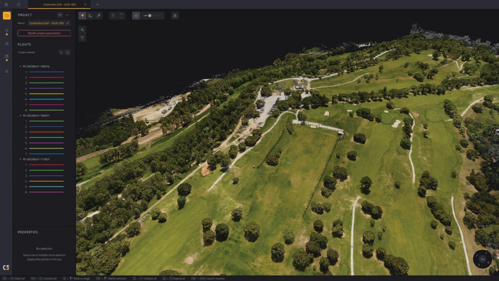
The name instead refers to the Lidar data (point clouds) generated by YellowScan’s sensor packages, which can periodically consist of such large files that uploading them to a cloud would make little sense compared with keeping the software desktop-based as it is.
“In future development for this software, we anticipate prioritising faster processing and streamlined user experiences. So, we’re working on algorithms we can put into YellowScan CloudStation to push the quality and also diversity of deliverables it can help users produce,” Dr Allouis added.
We met with Fullymax, a manufacturer of battery cells and packs based in Huizhou, Guangdong (China), which attended the show to present some of its latest UAV-suited energy storage solutions for increasing UAV flight times and payload carry capacities.
“Our LG4 Series, for instance, is our high-voltage [23.5 V] platform, with 4.45 V DC per cell, and up to 32 Ah per pack, with a continuous discharge C-rate of up to 10,” said Kevin Hu of Fullymax. “It’s proven very popular among heavy payload-carrying UAV manufacturers for its extended cycle life of at least 1000 full-depth discharge cycles and its working temperature range of -40 to +60 C.”
The company also unveiled its new NiS1 Series of high energy density 6S packs, which offer up to 36 Ah with 21.6 V DC output (781.9 Wh) and 2.5 kg total weight. The systems are Fullymax’s highest energy density products, enabled via a new 350 Wh/kg semi-solid-state cell technology with up to 4.2 V per cell.
“We’ve designed, manufactured and packed cells for about 24 years at our factory in Huizhou, working with a range of customers around the world. So, we’ve been able to both understand and learn from the geospatial surveying organisations at this expo and ones like it,” Hu added.
Hexagon NovAtel showcased its GAJT-310 Anti-Jam Antenna system, which is designed as a highly SWaP-optimised CRPA system.
“The GAJT-310 has three antenna elements, allowing the system to create independent nulls in two directions to mitigate jammers. The system is classified as a dual-use item, allowing for streamlined export approvals compared with other anti-jam antennas,” said Richard Coulton from NovAtel Positioning Division, Hexagon.
The GAJT-310’s housing is 132 mm wide and 51 mm tall, with a total weight of 545 g. It can track and null jammers in GPS L1, L2, Galileo E1 and BeiDou B1C simultaneously, while allowing other GNSS signals to pass through to the receiver, and it can be mounted with either a pole mount, flush mount or NATO mount system.
TinyMobileRobots exhibited at the show with its TinySurveyor robots, which come in two distinct configurations or versions for different applications, while running similar workflows and software.
“The major difference comes down to the terrain or surfaces each one is engineered to handle: the smaller TinySurveyor Plotter is ideal for roadworks or construction, and so it’s equipped with some frontal obstacle detection sensors and a beacon for making it visible at nighttime, given that roadworks often continue through darkness or other low-visibility conditions,” explained Per Kristensen at TinyMobileRobots.
The larger TinySurveyor Terra is built with larger wheels to traverse softer or rougher terrain. It lacks the Plotter’s high-wheel resolution of around 2000 points per wheel rotation (for ensuring pinpoint accuracy in lane marking or painting work, for instance), having just 360 points per rotation, although both perform similarly with respect to GNSS (TinyMobileRobots selects as many high-grade satellite receivers as it can muster).

“And the Terra is suited to dirtier work, like precisely marking out, say, 100,000 pole placements in grass or earth for solar power parks – so that an engineer can follow behind to mark each spot with a pole or nail – or setting up music festivals. Essentially, all the major festivals in Denmark and several in Germany and Belgium are now set up first by TinySurveyor Terras,” Kristensen notes.
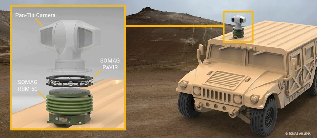
We spoke with SOMAG about its new passive vibration isolation ring (PaVIR) system, which it can customise to fit its own gyrostabilisation mount solutions as well as user-specified, application-specific vibration and harshness cases.
“We have a demonstration layout here, built to fit our most compact gyrostabilisation mount – the ruggedised, maritime RSM 50 – but we can adapt it for practically all of our mounts, be it our airborne, land or maritime systems, so long as we can understand the weight and shape of the customer’s payload,” said Sören Lieske from SOMAG.
Lieske added that the benefits of PaVIR include increased equipment lifespans by reducing mechanical wear and vibration-induced failure over time, improved video and imaging quality by eliminating motion blur, jitter and sensor instability during operation, and ease of installation and maintenance through not needing wiring or power as a mechanical-only solution designed for quick integration into harsh environments.
It is also constructed from rugged materials for harsh air, maritime and land conditions, and for key robustness properties such as corrosion resistance and shock durability. Those materials and parts typically include a plethora of metallic rings, designed with bridging interfaces and bolted as needed to route and mitigate vibratory loads per the use-case’s specifications and requirements.
SBG Systems unveiled Qinertia Cloud, which is a cloud-based version of its Qinertia GNSS software for achieving high-accuracy GNSS-only static positioning, as well as kinematic trajectory processing via PPK or PPP mode for navigation planning.
In addition to only requiring a web login over occupying hard drive space and computer memory, the new cloud system enables simplified workloads over the desktop version, through features such as drag-and-drop data uploads, single-button processing launches and the capacity to start receiving processed trajectory results by e-mail within minutes (or even immediately) following processing being initiated.
“Qinertia Cloud supports different processing modes. For instance, users don’t need to build base stations or work to access them nearby – as is the case for RTK-GNSS – because this online solution already includes a free base station network to launch PPK with just one single base station,” said Léa Lian from SBG Systems.
“Or, if the nearest base station is a bit far away, or not in good status, then Qinertia Cloud has the capability to build a virtual base station they can use for close-accuracy estimations of relative position and trajectory.
“And for really remote surveys, even in the middle of the ocean, the Orbi-AR PPP solution [‘Orbi’ being a brand name, ‘AR’ meaning Ambiguity Resolution] uses signals from satellites as references to calculate exact positions of static points or kinematic trajectories. That’s a new PPP technology from SBG in this space, which enables 2–3 cm of navigational accuracy via both Qinertia Cloud and Qinertia’s desktop version – higher accuracy than PPP float – without needing base stations at all.”
SBG is also working on a MEMS-based gyrocompassing unit, which will enable finding of True North on inertial technology alone without relying on GNSS or magnetometers.
UPCOMING EVENTS


