









GNSS

(Image: Uvify, courtesy of Septentrio)
Altering the deal
GNSS receivers are being geared for closer integration with uncrewed vehicles, other sensors, new satellite constellations and correction services, as Rory Jackson investigates
One might be forgiven for assuming, amidst the omnipresent discussion centred around the dangers of jamming and spoofing attacks, that uncrewed systems manufacturers were in the middle of a grand transition away from conventional GNSS-based navigation, to one or more of the supposed alternatives that might be immune to the designs of hostile agents.
But a closer look makes clear that GNSS will remain a critical lynchpin of uncrewed vehicles’ navigation systems, likely for another few decades at least. Neither optical, SLAM nor navigation-grade inertial systems can operate freely from GNSS signals for any length of time significant enough to suggest that the use of satellites for position, navigation or timing (PNT) data can be forgone entirely. Even self-driving trucks moving freight via highways (arguably the most GNSS-independent of all outdoor, above-water uncrewed systems, owing to their primarily using HD Maps and similar solutions for localisation) periodically rely on GNSS to validate their location, heading and timing data.

Hence, GNSS suppliers have spent the last few years toiling from product strategy meetings through to prototype lab and flight range tests, so that new products can be offered for all kinds of customers in 2026 and beyond. Specific advancements in GNSS receivers themselves (or transceivers, as they might be more correctly referred to) are cumbersome to unpack, owing both to their manufacturers closely guarding certain board- and chip-level innovations, and to the technical maturity of GNSS receiver products in general. However, a great deal of recent movement and growth is observable in the ecosystem around the receivers, from satellite constellations in space, down to base stations on the ground, and integrations with other sensors on board uncrewed vehicle platforms.
Meanwhile, as uncrewed systems proliferate into myriad new applications, GNSS suppliers are iterating new product architectures and configurations to suit the different cost, capability or interoperability requirements of modern use-cases across both civilian and defence markets.
Diversification
Indeed, GNSS suppliers have themselves made a great transition over the past four to five years. Previously, the global names in PNT solutions were predominantly dedicated to innovating and delivering products for large industrial vehicles and applications, from automotive and personal devices at the smaller end, up to packages for maritime shipping, construction, mining and other huge, manually-operated vehicles at the larger end.

(Image: Trimble Applanix)
But recent years have seen such suppliers show a clear and emphatic pivot, with UAVs and other robotic vehicles now being a standout imperative for GNSS product strategists given their rapid and as-yet unabated growth. Across the board, this has driven stringent optimisations, not only for SWaP-C (which are critical for defence and civilian integrations alike) but also manufacturing speed and supply chain resilience, to enable high-volume outputs for applications ranging from swarm-like drone light shows to uncrewed military aircraft.
Much of this has been building over time with the gradual rise of commercial applications, particularly in terms of UAV services progressing from R&D and demonstration phases to real-world rollouts. Paramount among these are UAV-based logistics across both last- and middle-mile distances, including medical deliveries, tools for heavy industry, and agricultural work including spraying and seeding.

However, with sudden soaring demand for advancements in defence technology driven by mounting geopolitical instability, GNSS suppliers have responded to calls for both lower-cost solutions for attritable or dispensable UAVs (including autonomous munitions-type systems, which have come to use GNSS, unlike guided ordnance of the past), and higher-cost solutions for tactical- or strategic-grade aircraft that must navigate unimpeded by natural or human-made disturbances.
One should not, however, assume that ‘lower-cost’ means low performance. Autonomous munitions, for instance, may need to fly with incredibly high speeds and dynamic manoeuvring, mandating very precise combined satellite and inertial systems with fast update rates and minimal latency. And uncrewed maritime and off-road systems must similarly operate with high precision, particularly when used in dual antenna configurations for heading data, and when coupled tightly with communications systems to synchronise timing data for warzone-critical ISTAR or mesh relay work.
Hence, the more low-cost, SWaP-C-optimised devices are not merely reconfigurations of existing tech utilising cheaper or more easily-assembled components, but carriers of significant new innovation. These can include software- or silicon-level optimisations developed to enhance performance metrics (such as Time to First Fix, timing accuracy or out-of-band noise rejection) while working within reduced budgets for power consumption, heat dissipation area, or space for low-noise amplifiers and band-pass filters.
Alternatively, some receivers for UAVs accommodate existing technology into very small, chip-sized OEM-type solutions to minimise their SWaP footprint, while those same receivers can be presented in enclosures for autonomous ground and maritime vehicles to guarantee their lifespan against repeated hard impacts from traversing waves or rough terrain.

Many of the benefits of these advancements will not be immediately visible on product brochures or data sheets. Unlike, say, engines, where one can see upticks in horsepower or downticks in fuel consumption presented in clear numbers or charts, improvements in GNSS receiver products are difficult to evidence outside of their interoperability: how successfully they are adopted and deployed in inertial navigation systems (INSs), how easily they work in dual antenna or multi-sensor fusion arrangements (including with closed military devices like M-Code GPS receivers), what aviation or military standards they meet, or how smoothly they provide accurate and sustained PNT data to INSs or flight controllers for hours at a time amid high shock and vibration, severe climates, or jamming and spoofing.
Thus, real-world integrations, tests and demonstrations are vital for gauging the true value and reliability of a next-generation GNSS device (for which GNSS suppliers are typically more than happy to provide test units to such ends, having likely invested hundreds of hours into validating the components, designs and performance of each new product before introducing or soft-launching them to the market).
All of these innovations and technical lessons for the defence world are expected to carry over into commercial applications, be it for tracking logistics operations, improving data precision and usefulness for mapping and inspection, or enhancing response times and operating effectiveness for emergency services. Hence, whatever R&D costs are being borne now, they will likely pay off for GNSS suppliers making such investments far into the future.
Testing
While exhaustive anechoic chamber testing and simulations are vital for many other RF-based solutions, high-end GNSS suppliers to the uncrewed space are more predisposed towards real-world testing, given the importance of getting GNSS receivers to work optimally at the system level (of INSs, autopilots and vehicles), and amid real-world climates, airspaces and band congestion, rather than in isolation or lab conditions. In absence of these, an actionable simulation or digital twin would have to include realistic recreation of the receiver’s immediate environment, changes in UAV attitude, the interferences of other RF signals or proximate electronics, ionospheric disturbances, the movements of satellites overhead, and many more factors besides – no easy task.

Hence, collaborations with beta testing partners are highly sought after to get proposed new receiver designs flying onboard aircraft early and often prior to commercial release. While almost any kinds of partners will do, it is not unusual for GNSS engineers to have a particular penchant for working with Chinese UAV companies because such manufacturers have proven extremely willing to give lengthy, detailed and unabashedly harsh technical criticism of how new navigation prototypes present at the system level (an invaluable sort of feedback for competitive GNSS suppliers).
Moreover, the relative lack of dialogue between Chinese and English-speaking uncrewed systems companies means that the technical details of such exchanges are practically guaranteed to never leak to prospective customers or rivals anywhere west of China until the supplier is ready to start announcing the new product more widely. But, naturally, developers of high-end GNSS equipment will not fail to perform tests with the exact, intended customer of a new prototype (both in mission and geographical terms) for at least a year or two before offering the product version to that customer and others like them.
Testing receivers against jamming and spoofing is more challenging because the asymmetric and unpredictable nature of such attacks and those performing them can make it dangerous to assume that controlled test results are indicative of real-world resilience. However, a significant number of hackathon-type, jamming-focused events are open for GNSS suppliers to participate in – some closed, military-oriented jamming events can also be accessed with the right resources and discussions. But, ultimately, actual warfare – regrettable it may be that it is present in the world today – is inarguably the ultimate testing ground for GNSS performance against hostile players, with those suppliers fielding products and prototypes in Ukraine or the Middle East garnering indispensable test data and feedback for future optimisations.

Beyond specific verbal feedback from real-world tests, there is also mounting use of AI-powered imaging to screen new GNSS prototypes and products, from laboratories to manufacturing centres, which can be automated to help speed in-house development loops and shorten the time to real-world experiments (and the greater value the latter can represent).
Jamming and spoofing
Many of the ideal techniques adopted for keeping receivers resilient against hostile attackers go into the elements within the core chipset design, with GNSS chips optimised through the necessary decades of expertise performing practically as well as some controlled reception pattern antennas (CRPAs) in terms of rejecting hostile signals.

(Image: AGR, courtesy of Septentrio)
Essentially, designing and fabricating GNSS chips inherently capable of rejecting jamming or spoofing attacks comes down to how well the chip has been architected to track each of its pertinent GNSS satellite constellations and signal frequencies independently. Many suppliers will reduce R&D and production costs by designing a simpler chip that tracks multiple frequency groups simultaneously (and thus indiscriminately), thereafter filtering only for blatantly out-of-band signals.
(Image: SBG Systems)
Such an approach, however, robs the receiver of some of the best forms of filtering, such as the ability to compare or cross-reference individual signals in a way that enables conclusive measuring of disturbances among them. Designing the receiver for integration with a specialised null-forming antenna, like a CRPA or Low Elevation Angle Nulling Antenna, can compensate for lacking such capability – but a more reliable approach would be combining such an antenna with a robust chipset for comprehensive anti-jamming and -spoofing.

Significant resilience can, however, come from software alone, like smart algorithmic detection and rejection of spoofed position, guidance or heading data or algorithmically steered rejection of jamming. Programming such capabilities is functionally similar to software-defined mitigation of multipathing errors or ionospheric disturbances. Hence, the learning curve or barriers against such advancements is reduced compared with baking resilience into the bare silicon.
Whether relying on hardware, software or both, it is important that a GNSS receiver can track as many signals as possible, not merely for maximising the vehicle’s or INS’s access to satellite navigation data regardless of location or attitude, but also for ensuring backup signals when one or many are rendered unavailable by attackers. Low-Earth orbit (LEO) satellites for PNT are anticipated to help greatly in this regard, with companies such as Xona, TrustPoint and Parsons Corporation working towards these, to the interest of GNSS suppliers – some of whom are already testing receiver prototypes designed to track signals from such companies’ equipment, with experimental data indicating up to 20 dB of improvement in resilience through their inclusion.
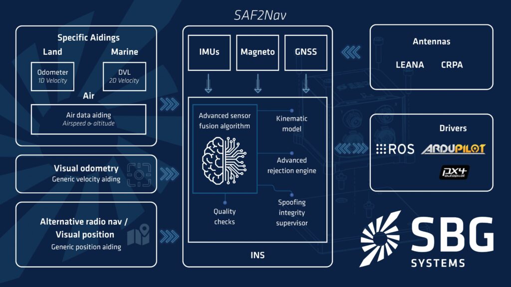
While commercial rollout of LEO PNT constellations may take another two to three years, there are more present means of protecting against jamming and spoofing at the system level. As evidenced by defence UAV manufacturers like Primoco (see UNC-51), where prudent use of existing flight sensors – such as IMUs, air data systems or optical flow-type sensors – can enable integrity checks for when attackers feed incorrect airspeed, attitude or heading information to vehicle operators at their GCSs. Analysing the unjammable data from inertial, camera, wheel, air speed or pressure sensors can evaluate against mismatches with incoming GNSS position data. Hence, receivers designed for close synchronisation with other sensors (including a robust software framework that compares sensor datasets, detects inconsistencies and rejects unreliable measurements to maintain safe navigation when GNSS can no longer be trusted) as part of an integrated flight avionics package can make the difference between mission success and failure for UAVs.
Software engines
While GNSS hardware is subject to continuous iteration and adaptation, many of the actual advancements in navigation systems today come not from the receivers themselves but from the external systems they integrate with, including inertial sensors, cameras, radars and laser sensors.
Software is the primary differentiator between a quality fusion between the GNSS receiver and other sensors, and a poor one, with the GNSS engine forming the starting point for ensuring consistent, reliable satellite data from the outset.
A loosely-coupled GNSS engine has the receiver compute a complete position fix independently of the INS before delivering it downstream, requiring four visible navigation satellites overhead – a tough ask in many environments. Without four satellites, the receiver outputs no fix and drift can accumulate. Conversely, a tightly-coupled system works directly with the individual raw data per satellite, meaning even one satellite can update an uncrewed system’s PNT data and reduce drift.

(Image: OXTS)
Thus, newer engines programmed for tight coupling can deliver particular improvements in the availability of position and heading data over mission durations – on the order of 15–20% more GNSS data in some modern cases – as well as high-accuracy positioning and georeferencing at distances greater than usual from real-time kinematics (RTK) base stations, up to 60 km away in some cases, reducing the need to assemble new base stations when operating in remote areas.

Quality GNSS engines will also enable compatibility, advanced fusion and filtering with other vehicle sensors (with some engines even integrating pathways to infer navigation intelligence from onboard sensors not originally meant for navigation, such as gimbal-mounted IMUs meant for target tracking and georeferencing). In addition to continuously refining GNSS inputs, embedded algorithms and subroutines for correcting ancillary sensor issues such as installation offsets, bias or drift can result in huge compound gains in navigational integrity at the system level, when the tightly-coupled satellite data are fused with those from inertial sensors, wheel encoders, pitot tubes, Lidars, cameras and other systems.
Self-driving automotive and near-road applications in particular (such as delivery robots) are calling for engines that can periodically employ robust dead reckoning algorithms and leverage optical, laser and radar data when RTK-GNSS information briefly becomes unavailable. The primacy of RTK in that approach is important because it ensures – should the GNSS fix be lost – that centimetre-level accuracy had, at least, been utilised up until that point, giving the vehicle better prospects for maintaining navigation integrity in real-time than if RTK were forgone.
RTK networks
For missions requiring the highest echelons of real-time positioning accuracy, a small number of RTK corrections suppliers now offer positioning enhancement services – with a smaller number still of standouts owning their own base station networks – which can be immensely cost-efficient for markets such as geospatial mapping, logistics or agriculture where pinpoint GNSS accuracy is a constant requirement.

A good RTK network depends first on good base stations as a foundation. Much of the industry around base stations has become more flexible with time in how it approaches their design and construction. While this has yielded some technically advanced network nodes, some RTK service providers will alternately opt for crowd-sourcing or deploying low-quality base stations, which can diminish the reliability and hence safety of operations compared with customers’ expectations.
The first article of a good base station is that it provides clean raw signal data through integrating high-end GNSS receivers. Using similar receivers to those on low-end uncrewed or self-driving vehicles, or indeed almost any mobile application, is a cost-saving approach often seen in low-quality base stations that will cause the ensuing correction service to fall at the first hurdle of accuracy requirements.
Then, a well-designed antenna must be positioned clear of interference from other subsystems. Hence, making the base station too compact (for easier transport and installation, for instance) risks squeezing and muffling the antenna amid EMI or other hazards, whereas ideally it would be isolated to ensure quality signal data with minimal carrier noise and a maximal signal-to-noise ratio.
A few systems can then ensure the long-term consistency and reliability of each base station and its network. An energy-dense backup battery, for instance, maximises station uptime amid power outages from connected grids or solar panels, with some RTK stations working up to seven days without input power. That same uptime can extend through network provider dropouts if dual or more SIM cards are integrated for seamless network hopping.
And, although it might sound odd, some RTK network owner-operators even integrate inertial sensors in their base stations, such that a given base station can be automatically removed off the network in the event of incongruous and excessive movement readings in the monitoring backend (which can be indicative of weather events, vandalism, tectonic plate shifts or other potential sources of damage to the station).
Lastly, the very highest-end RTK providers will survey each of their base stations daily via independent or public-sector base station surveyors, which can be vital for validating station conditions and hence the integrity of the overall network.

Oftentimes, customers of RTK correction services will happily provide space for the construction of new base stations and expanding networks to help them; for instance, atop their own offices, or near assets that they would like routinely surveyed by uncrewed vehicles, such as power lines, harbours or solar panels.
However, government regulation is typically the firmest barrier to RTK network expansion, above component sourcing and issues of climate, weather or geography. Different countries across the EU, for instance, will have different regulations pertaining to RTK networks, with some treating them identically to internet service providers (ISPs), requiring base station installers to go through ISP training and other unnecessary hurdles that can add months of lead time. Hence, any competencies or efficiencies that RTK corrections providers can learn to speed the planning, construction and onboarding of new network nodes (and anything else within their control) can be vital for customers trying to realise the real-world benefits of uncrewed systems in operation.
Future
Going forwards, high-end GNSS receivers for autonomous systems will continue evolving from simple, single- or dual-band devices into full-constellation, multifrequency systems, and support an increasing number of local constellations and correction services as they come online. Minor mechanical enhancements in areas such as vibration protection, IMU damping and resonance reduction stand to go a long way towards GNSS products’ lifespans and, hence, their long-term reliability and ROIs.
(Image: Point One Navigation)
INSs may develop at a slower pace than the GNSS receivers themselves, owing to the greater calibration, qualification and manufacturing requirements. However, there is immense untapped ground in terms of software enhancements to GNSS and INS products, particularly with respect to how algorithmic or generative AI may be used to detect interferences or disturbances and then reject them from navigation data to protect military UAVs from jamming and spoofing attacks, or guard commercial UAVs from multipathing or spectrum congestion effects. Advancements in sensor fusion and machine vision will also be vital for visual navigation systems and other multi-sensor approaches utilising GNSS as a core – but not sole – component of aircraft positioning and guidance.
And although much of GNSS suppliers’ attention is focused on UAVs, companies are keeping a trained eye on UGVs and other off-road robotics applications requiring navigation solutions capable of working in remote, forested, mountainous or otherwise challenging environments. Because these are used in warzones such as Ukraine at an accelerating rate, many expect UGVs to become a major market for new GNSS products on par with UAVs.
Considerable lessons and advancements may meanwhile be gained from other sources entirely beyond uncrewed vehicles. A growing array of GNSS-tracking wearables and IoT devices, for instance, are racking up mileage and data across different real-world environments that can feed back into different technologies.

These may also feed into different ancillary services, across GNSS corrections, enhancements or security, not only from terrestrial sources but also from LEO and potentially the cloud – although which of these will be deemed most imperative to the changing winds of defence and commercial markets remains to be seen. But while unstable forces may govern the world’s future in a broad sense, a steady hand and robust approach to the building blocks of GNSS hardware and software have proven (and will likely keep proving) ideal for at least keeping track of our uncrewed fleets and systems all the while.
Acknowledgements
The author would like to thank Gustavo Lopez of Septentrio, Yoann Plenet of SBG Systems, Dr Mohamed Mostafa of Trimble Applanix, Jonathan Deacon of Oxford Technical Solutions, and Gabe Amancia, Michael Leppitsch and Kevin Lam of Point One Navigation for their help in researching this article.
UPCOMING EVENTS