


Dr. Richard Dowdeswell
AI-aided sonar is taking uncrewed vehicles where no hydrographic surveyor has gone before, GeoAcoustics’ co-owner tells Peter Donaldson
Great expeditions
When Richard Dowdeswell was headhunted in 2017 to turn around the long-established but struggling Kongsberg GeoAcoustics, his knowledge of the technology at the heart of the business was more than somewhat limited. “I had no idea about sonar,” he admits. “One of my colleagues had a book on the fundamentals, which I read, and from then on it was a very steep learning curve.”
However, Dowdeswell’s scientific and engineering background helped him along that curve, and he was able to draw on his experience with gas-sensing instruments at Manchester University. He used optical and then electrical instruments to measure contamination in liquids, and even ‘electronic nose’ technology that gauged the electrical properties of gases. All of this was underpinned by a deep curiosity about how things work and a habit of lifelong learning plus crucial early experience with that suddenly ubiquitous technology known as artificial intelligence (AI).
Early voyages
Much earlier, Dowdeswell was introduced to the sea. Although he was born in Kidderminster, a small town to the south of England’s second-largest city of Birmingham and almost as far from the coast as you can get in the British Isles, he spent three of the first five years of his life aboard ship. His father was a captain in the Merchant Navy, who lived aboard with his wife and small son while in command of 30,000 t bulk carriers on routes between the UK, Europe, Africa and the Americas.
When the time came for him to start school at five, his father took a desk job in ship management in London and Dowdeswell spent most of his time in Cheltenham, Gloucestershire, where he attended primary and secondary school. Degrees in engineering, science and management followed, lining him up for a career in which taking measurements and handling data have been central.
“For my entire career, I’ve been involved with instrumentation of one form or another,” he says. “The front end of a sonar is different because it deals with sound rather than light or other phenomena, but once you have turned that into an electrical signal, processing it is the same sort of task.”
However, turning the company around demanded people skills rather than addressing any shortcomings of a solid and in-demand product range. The task centred on what he calls a “charm offensive”, conducted to re-establish and nurture relationships with sales partners around the world, particularly in Asia, addressing their concerns and reinforcing after-sales support.
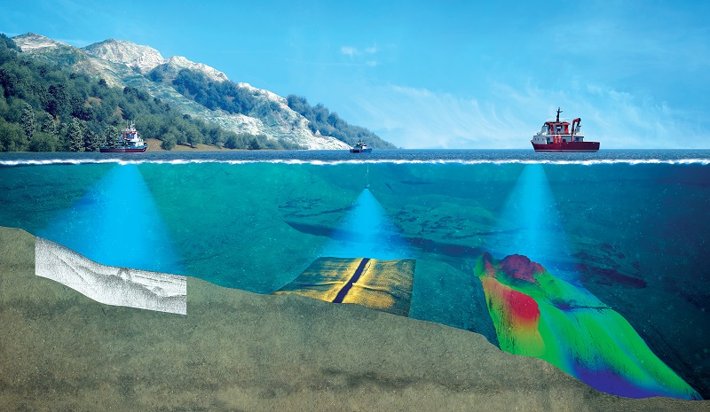
GeoAcoustics offers a range of underwater sensors, including side-scan sonar, interferometric sonar and sub-bottom profilers, all of which can be towed by or mounted on relatively small, uncrewed vehicles, including USVs and UUVs/AUVs. These systems are sold through a network of ‘channel partners’ spanning about 70 countries.
“My role is predominantly to support them to make sure they have the information and tools they need to sell our products in their local markets,” Dowdeswell says.
Most of the company’s work over the last few years has been the integration of the GeoSwath sonar onto USV platforms, including the Teledyne Z-Boat, the SeaFloor Systems Echo Boat, the OceanAlpha SL40, the Inception from Unmanned Survey Solutions, the SB 100 from GPA SeaBots and Martac Systems’ Mantas T12.
“The use of USVs has opened up hydrographic surveying to a host of areas that previously were inaccessible to traditional survey vessels,” he says.
The development of acoustic sensor technologies has also been affected by the demands of uncrewed vehicles, particularly smaller, battery powered machines with limited onboard energy. This has reduced the size of transducers and processing electronics to reduce their power demands. “In terms of physical size, there has also been a driver to make the transducers smaller to reduce drag on the vessel, and so prolong the time available to the vessels for surveys,” Dowdeswell says.
Rejuvenation through AI
Inevitably, there is more to it than that, and Dowdeswell is also overseeing the rejuvenation of the computing elements of sonar systems, partly through the application of AI. He explains: “AI and machine learning have brought big improvements to the processing and interpretation of sonar data, primarily for object detection and recognition related to side-scan sonar and also to bathymetry.”
He says much of the pioneering work with AI applied to sonar had military applications, such as in mine countermeasures, for example, and it is still a very active area. “So, you may be looking for a cylindrical object on the seabed and to differentiate an oil drum from a mine. That’s where a lot of the industry’s r&d has been.”
More recently, offshore construction of wind farms and their associated cable routes has come to the fore, and there is a lot of AI development going into the recognition and counting of boulders, which can be major obstacles to the installation of such infrastructure, and the set of applications is broadening.
“Within the field of AI there are various branches, but the main division is between supervised or unsupervised approaches. In supervised approaches, you have raw data, you have the finished result, and you train some form of AI – generally a neural network – to map input to output. And that’s what I was doing 30 years ago with optical spectra,” Dowdeswell recalls.
This was his PhD project, and it involved examining liquid effluent from a brewery in Bedford using a spectrometer to measure light wavelengths across a spectrum, revealing gaps in the normal spectrum caused by something absorbing particular wavelengths.
“What it was looking for was abnormal instances where someone had left a valve open and the effluent was being contaminated – pollution breakthrough. You trained it on lots of examples of normal effluent and then told it to flag up something it had never seen before, an exception,” he says.
“One analogy I sometimes use is: if I wanted an AI to tell the difference between dogs and rabbits, I would give it lots of pictures of dogs and rabbits, all labelled. The network would then build up a way of analysing a picture and giving you a determination.
“If I then gave it a picture of a little pug with rabbit ears stuck on, it may struggle if the network says the dominant feature of rabbits is two big ears poking up, as it would go for that, whereas it might say there are other features of a dog that are dominant in determining whether it is a dog.
“Such supervised AI is fine so long as what you’re asking it to do is within its knowledge base, whether it has been trained on it. If you give it something that it’s never seen before, it will give you an answer, but your confidence in its output will not be as high as it would be if the example were in the training set.
“With bathymetry, we took the unsupervised approach, because in order to cover every example that you might want to survey – sandy and rocky seabeds, coral reefs, wrecks, harbour walls, etc – you would have to give it labelled examples, and in different water conditions at different depths that’s an awful lot of data,” says Dowdeswell.
In unsupervised learning, the algorithm is given an unlabelled dataset and tasked with finding patterns or structure within the data on its own, without explicit guidance. Presented with new data, unsupervised learning algorithms typically focus on uncovering hidden patterns, similarities or relationships within the data.
When Dowdeswell joined the company in 2017, he found that processing raw sonar data was a pattern recognition problem, so the company started an r&d programme with a team from the Computer Science Department at the University of East Anglia. They included two master’s students, one of whom focused on supervised AI while the other took the unsupervised approach. “Both worked reasonably well, but there’s a lot of effort that has to go into providing supervised AI with labelled data, which is why we went down the unsupervised route.”
AI for interferometric sonar
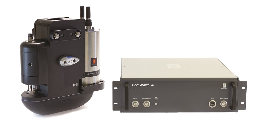
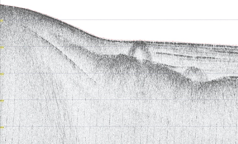
The first of GeoAcoustics’ sensor systems to benefit from AI is the GeoSwath interferometric sonar, which Dowdeswell contrasts with multi-beam echo sounder (MBES) echo sounder, although both achieve the same bathymetric output. Because systems based on interferometric technology create an order of magnitude of more data points per ping than an MBES, the processing has always been more involved.
Both MBES and interferometric sonars generate multiple simultaneous beams and measure echo-return times, while the latter also measure phase differences between the beams, requiring more sophisticated algorithms.
Dowdeswell says that using AI has dramatically lowered this hurdle, so data can now be processed in real time on the vessel.
“What we’re looking for is continuous structures; the seabed is a continuous structure – mooring lines in the water and harbour walls are continuous. So, it examines all the data, looking for pockets of data that are connected to other pockets that would then create features, and there is some reinforcement learning in there,” he says.
“The first ones have been tweaked to make them better and we’re constantly asking for customer feedback. If they’ve got a data set that isn’t doing as well as they hoped it would, we invite them to send it to us so we can – maybe – improve the model.”
In one early application of the technology, GeoAcoustics is cooperating with hydrogen-powered USV developer Acua Ocean and Unmanned Survey Solutions on a nine-month Innovate UK project to find and map environmentally important seagrass beds off the coast.
“The plan is to use the GeoSwath to look for the seagrass, and there’s a large proportion of AI embedded in that to look at the data. Here, we’re not only looking at the bathymetry, but also at the intensity of side-scan sonar returns to try to determine the presence or absence of seagrass,” Dowdeswell explains.
When that mission is complete, he intends to turn his team’s attention to applying AI to the company’s sub-bottom profiling sonar, which is used to find discontinuities in the seabed, including layers of sediment of varying density, and buried objects such as pipelines and wrecks.
One data-processing challenge lies in identifying and eliminating unwanted reflections that reverberate multiple times between the seabed and the sonar towfish and give the false impression of real strata. A second and more complex problem is detecting structures in sub-bottom data.
“I think that will probably need more of a supervised approach; training it based on lots of data examples that have been analysed and labelled by geophysicists,” says Dowdeswell.
By combining advanced AI for vessel control and processing sensor data, he believes it should be possible to automate the whole survey process. “Having launched the vessel, the operator can rely on it to undertake adaptive survey line planning, based on real-time feedback of the coverage area, enabling the survey to be conducted more efficiently and providing confidence that the survey coverage meets requirements,” he says.
Bringing AI into sensors for uncrewed systems is the project that has given Dowdeswell the most satisfaction. Despite the complexity of the technology, his philosophy of engineering favours simplicity wherever it is practical.
“We try to keep the solution as simple as possible, and make sure that what we are designing and making is what the end-users actually want,” he says.
Dr Richard Dowdeswell
Born in 1970, Dr Richard Dowdeswell is chief commercial officer and co-owner of GeoAcoustics, where he leads a team of 23 people in design, manufacturing and product support, working alongside his wife, Linda, who is general manager.
At school, his favourite subjects were physics and chemistry, while geology and rock collecting were his main hobbies.
“I had understanding parents, who would humour me with trips to abandoned mines to pick over the spoil tips, looking for new specimens, some of which are still in my collection,” he says.
At Leeds University, Dowdeswell turned his enthusiasm into a bachelor’s degree in mineral engineering, which he followed with a PhD in instrumentation and management from Cranfield University. Later came a BSc from the Open University, combining oceanography, database design, Visual Basic application development, cosmology and astronomy, followed by a master’s in commercial law from Northumbria University.
His first job was as a research associate at the University of Manchester (UMIST) working on novel instrumentation systems. In 1999, he founded the Keiku Group as a spin-off to commercialise water-quality instruments for the brewing industry.
A decade at the UK’s Centre for Environment, Fisheries and Aquaculture Science followed, ending in 2017, when Dowdeswell was headhunted to run Kongsberg GeoAcoustics, which he took to independence as GeoAcoustics in December 2020.
UPCOMING EVENTS


