


CUAV Expo 2024
Peter Donaldson guides us around a selection of enterprising products on show at Commercial UAV Exp
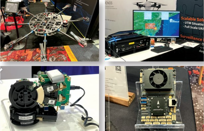
Staged in Las Vegas on September 3-5, the Commercial UAV Expo put the spotlight on a wide range of new and improved products and services. What follows is our selection of innovations focusing on platforms, powertrains, flight control, sensors, navigation and positioning, secure communication, data handling, vibration mitigation and end-to-end capability provision.
Accipiter showcased its scalable, airspace awareness technology for UAS operators, serving industrial and public safety customers. “Our all-domain awareness and smart surveillance solutions empower UAS service providers to achieve beyond-visual-line-of-sight [BVLOS] operations through a multi-sensor, networked architecture approach,” explained Evan Nohara.
“Accipiter’s patented systems integrate data feeds from radars, cameras, automatic dependent surveillance-broadcast [ADS-B] passive radio-frequency sensors and remote identification systems, presenting live airspace, situational understanding in a single, common operating picture.”
Based on Accipiter’s Radar Intelligence Network (RIN) platform technology, its system detects and tracks cooperative and uncooperative targets – both crewed and uncrewed – and alerts the operator to possible airspace conflicts, so they can take timely evasive action and maintain safety.
“Customers working with Accipiter, UAS providers and the FAA have already been granted nationwide BVLOS waivers, and our airspace surveillance network is operational for a utility company that is flying drones to inspect infrastructure,” Nohara added.
As well as providing real-time situational awareness, Accipiter post-processes historical data and delivers analytical understanding for incremental risk assessment.
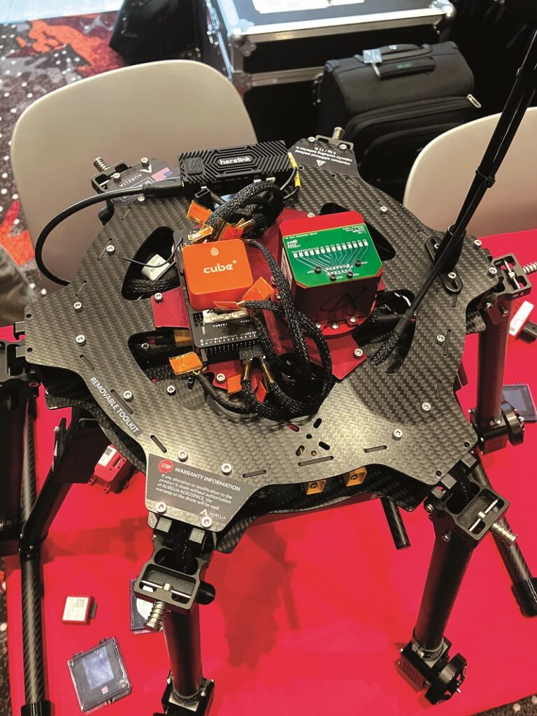
Aero Systems West presented its heavy Lift Multicopter industrial range. Built in the US, the UAVs can comply with Department of Defense ‘Blue UAS’ requirements for military and federal applications, based on where the vehicles and their components are made, said Daniel Neal.
The largest is the proven Heavy Lift Octocopter Industrial Drone. With a take-off weight of 43-72 kg, it carries payloads of up to almost 32 kg and can fly for over 50 minutes.
Motors, electronic speed controllers and propellers come from KDE, batteries from MaxAmps and the flight controller is Cube Pilot’s Orange Cube, with the Blue Cube optional for government requirements.
“The primary navigation sensor is a dual-blended setup of the Cube Pilot Here3+ GNSS system,” Neal added. “Almost everything else we either cut, manufacture, assemble or solder in-house.
“It’s a fully open-source system, so you can integrate whatever you want onto it. We’re a payload-agnostic, airframe OEM. Each customer wants a different payload and we will integrate that for them, or we can deliver the ready-to-fly aircraft and they can integrate it.”
The company also offers a hexacopter and a quadcopter on the same basis.
Airspace Link presented Air Hub Portal, through which the majority of US pilots access the company’s UAS-related information services. Rich Fahle emphasises its role in facilitating uncrewed flight operations, particularly through the Low Altitude Authorization and Notification Capability (LAANC) and as an FAA-approved B4UFLY flight-safety service provider, delivering information about controlled and special use airspace, critical infrastructure, airports and information on temporary flight restrictions for special events.
At the core of Air Hub Portal is technology that supports diverse UAS activities, ranging from corporate asset management to city coordination for public safety and logistics. The company helps cities prepare for future uncrewed operations, including inspection services, deliveries, and eVTOL air taxis.
Many cities are ill-prepared for this shift, and Airspace Link acts as a facilitator, helping communities understand the need for coordinated drone operations, Fahle said.
Fahle highlights Air Hub Portal’s unique features, such as integration with Esri’s GIS data, which provides real-time flight-safety information, easing flight planning. “We are the only app that has Esri’s GIS data integrated into the software,” Fahle explained.
Airspace Link’s technology is built on open architecture principles, allowing other service providers and technologies to be incorporated into the platform.
(Images courtesy of Peter Donaldson)
Anello Photonics discussed its silicon Photonics Optical Gyroscope (SiPhOG) miniature inertial-sensing technology for navigation in GNSS-denied environments. Gerhard Boiciuc said SiPhOG is the world’s first optical gyroscope on a chip, which brings greater accuracy than micro-electromechanical system (MEMS) gyros while being much smaller and cheaper than fibre-optic gyros (FOGs).
“The technology brings high-precision FOG performance in small-form factor on a silicon platform that can be scaled to high volume, which MEMS cannot do,” Boiciuc said. “The idea is to create something small, accurate, reliable and robust that’s not susceptible to temperature and vibrations, and easily used for autonomous applications.”
“The current bias instability for our first-generation product is at 0.5o per hour. Most MEMS are around 3-5o an hour or higher. Similar-performance FOGs are much bigger, consume more power and are much more expensive. A bias instability of 0.5o per hour seems to be sufficient for most autonomous applications,” he added.
Mario Paniccia said the core of the SiPhOG consists of a photonics integrated circuit (PIC). “This PIC allows us to integrate all the discrete components into a single chip.”
Available now are: the Anello X3, a three-axis inertial measurement unit (IMU) for aerial and maritime applications; the hardened, IP68-sealed Anello IMU+ for robotics; and the Anello GNSS INS, which combines two dual-band, five-constellation GNSS receivers with a six-axis MEMS/SiPhOG accelerometer/gyroscope for autonomous trucking and precision agriculture.
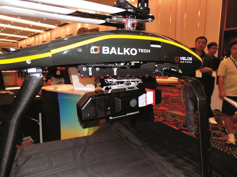
Balko Tech recently presented connectiv, which it describes as the second generation of the world’s first modular Lidar system for UAS.
According to Johnathan Smeh, the concept behind Connectiv is to mount the Lidar alongside supporting sensors – such as RGB (colour), thermal or multispectral cameras – together with an inertial navigation system (INS) and onboard computer onto a single chassis. This configuration ensures every sensor meets the same high accuracy.
The system on display was configured with a Riegl miniVux-3UAV Lidar, a Trimble Applanix APX20 GNSS/IMU module and a 61 MP Sony RGB camera, all integrated onto the Connectiv chassis. This setup was attached to an anti-vibration mount under a Velos V3 helicopter, but Smeh emphasises that the system is “drone-agnostic”, meaning it can be mounted on a variety of UAVs.
“The engineering challenge was building a rigid chassis with consistently precise sensor attachments, rigorously tested and calibrated to ensure data quality,” he said.
“Each sensor has a unique calibration profile. We build the system, then conduct multiple benchmark flights at our calibration sites to test the Lidar, cameras and INS. Each configuration undergoes extensive testing to create a profile that works with our software, combining all raw sensor data into a geolocated, colourised point cloud.”
Blue Marble Geographics presented advances in 3D data analysis, particularly point clouds, in their all-in-one GIS software, Global Mapper. The focus was on increasingly accessible tools that use machine learning to improve understanding of landscapes and built environments.
Lidar point clouds, once collected using manned aircraft, are more efficiently captured with UAVs, as they offer higher resolution and affordability, said Cassidy Barkalow.
“Point clouds are a very information-dense form of data… every single one of maybe half a million points can have an RGB value plus others like intensity, return number, and more.”
Classifying specific features in point clouds involves two main steps, Barkalow explained: geometric segmentation, where a computer separates the data into distinct objects (trees, buildings, etc); and semantic segmentation, which assigns meaning to these segments.
Machine learning enables custom classification, allowing users to identify specific objects, such as sand traps on a golf course, by training the system on a few examples.
“That is where we’ve got our tool for automatic custom classification, where you can train a machine-learning model yourself with just a couple of quick steps.” she added.
Blue Marble’s future tool development will focus on data fusion, improving ease of use and automating summary reports.
Calian showcased the newest, smallest and lightest members of its Tallysman GNSS antenna family, designed for ease of integration into uncrewed platforms. These include helical, patch and cross-dipole antennas, which combine compactness and low weight with high performance, according to Joseph Botros.
Calian’s standard, helical antenna weighs 42 g and measures 62 mm high complete with housing, while the new one is a centimetre shorter and 10 g lighter with the same performance.
Calian used the “filar meandering” technique to miniaturise the antenna, putting a sharper bend in the upper end of each active element to reduce height while keeping the length the same to preserve frequency coverage, Botros explained.
The company also offers a new “smart” helical antenna, the HCS885XF, which has a U-Blox Neo F9P receiver integrated into the housing. “You get the JST serial output from the bottom instead of an RF connection, taking the guesswork out of the integration,” said Botros.
Also on display was the SSL889XF, which he described as the world’s lightest and smallest precision, dual-band patch antenna. Patch antennas have a drag-minimising, low profile.
Finally, Calian showed its newest cross-dipole antenna, the SSL990XF, which, though a little heavier than a helical equivalent, provides reliable reception of GNSS signals in open-pit mines, under tree canopies or in urban canyons.
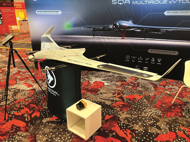
C-Astral Aerospace displayed the SQA, a fixed-wing VTOL UAV, developed from the catapult-launched Bramor in response to demand for vertical take-off and landing capabilities, according to Rok Tomazic. C-Astral has received the prestigious Red Dot Best of the Best Award in industrial design for SQA.
SQA offers a flight endurance of 2.5 hours and there are plans to extend this to three hours using higher capacity batteries.
SQA supports a variety of payloads, including EO/IR cameras, Lidar and photogrammetry systems. Tomazic noted: “We work case by case… if the client has any special needs, we can always adapt the system to them.”
Tomazic highlighted a project with the EU, in which it integrated YellowScan Surveyor Ultra Lidar for forest-cover mapping under the auspices of the EU Observatory on Deforestation and Forest Degradation.
SQA’s modular design allows for easy assembly and disassembly without special tools, while C-Astral’s proprietary control software simplifies flight operations through automatic waypoint following, but still offers manual joystick control for remote piloting.
Tomazic confirms that the system is already in production, with around 70-80 units in operation.
Riegl continues to develop its range of UAV-compatible Lidar sensors, focused on miniaturisation, advanced scanning and processing techniques, and multi-sensor integration.
The miniVUX-series, for example, embodies the company’s core Lidar technology miniaturised, offering lightweight, cost-effective, high-performance, 3D sensing capability, and bringing survey-grade accuracy to small, commercial UAVs.
My-Linh Truong highlights the 1.75 kg miniVUX-3UAV with the newly integrated Riegl location and orientation component (RiLOC-E) system, which integrates a MEMS IMU, a GNSS receiver and software.
“This is our lightest-weight integration yet, offering both Lidar and IMU capabilities all within the Riegl house,” she said, adding that this simplifies workflows, as users no longer need third-party hardware or software integrations.
Another recent advance is the forward and backward scanning technology in the larger VUX-12023 and VUX-16023 sensors. Traditionally, Lidar systems scan using a linear pattern, but these two sensors offer forward-and-backward scanning, providing more comprehensive coverage in fewer flight passes.
For operators seeking an extended range, the 2.7 kg VUX-18024 offers such capabilities while remaining compact.
Further, Riegl’s new open-platform mounting plate accommodates different combinations of sensors, cameras and IMUs.
Sunhillo Corporation showed its cutting-edge situational awareness solutions for BVLOS UAV operations, designed to enable real-time decision-making for operators.
According to Doug Walczak, its technology integrates radar data and ADS-B signals. “We can fuse that data to provide one surveillance picture without duplicate targets,” he explained.
Sunhillo’s Surveillance Monitoring System (SMS) features customisable visual and audible collision alerts.
“You will have time to get an alert identifying traffic nearby and an instruction to change course,” Walczak said. This tool also allows operators to see the same information as their command centre, enhancing coordinated decision-making.
Their solutions incorporate advanced hardware such as the US military-deployed Margate II ADS-B receiver, which boasts a 200 mile range, making it ideal for large-scale operations.
Looking ahead, Walczak highlights ongoing work on integrating Remote ID into the system. “We will have radar, ADS-B and remote ID, so you’ll be able to see UAVs as well as crewed aircraft,” he added.
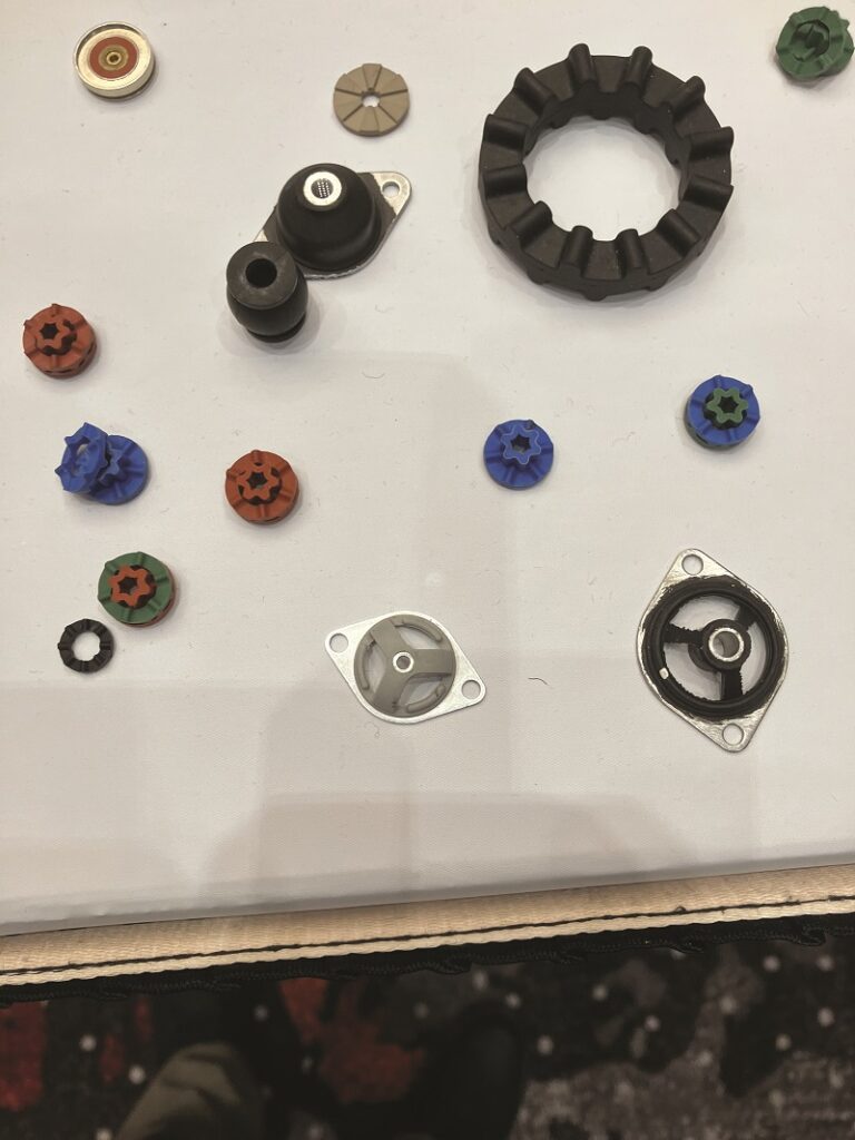
Greene Rubber Company, a specialist in shock and vibration mitigation since the 1930s, exhibited its growing range of isolation mounts designed to protect sensitive UAV components. Bob Schleicher highlights the company’s focus on adapting its aerospace-grade technology to UAVs. Its UAV-specific mounts are tailored for relatively small, light payloads.
One key advantage of these mounts is their dual functionality in addressing both continuous vibration and shock events such as hard landings. Schleicher explained: “Some mounts are shock-focused, some are vibration-focused and some have dual capability.”
For example, the UAV 3001 mount features equal stiffness axially and radially, allowing for versatile placement within the vehicle. It also incorporates a “snubber” for shock protection, ensuring that even if the isolator collapses, the force will be absorbed.
Schleicher emphasised that Greene’s mounts often outperform software-based vibration mitigation.
“It’s a very simple mechanical solution to a problem. It’s cheaper most of the time,” he said, pointing out that well-engineered mounts extend the life of critical components, while software solutions only address part of the problem by mitigating the effects of vibration on a camera image.
Taisync showed new versions of its secure UAV datalink radios with point-to-point, point-to-multipoint, mesh and relay capabilities, along with the new ViuRC7 remote controller.
The company offers wireless datalink modules supporting ranges of 3-300 km. The most popular, 2.4/5 GHz dual-band module can reach up to 15 km using the 2.4 GHz frequency.
Security features of the radios include AES encryption, adaptive frequency hopping and anti-jam capabilities, said Timothy Gu.
The anti-jam system operates on the principle of separating the uplink and downlink frequencies in response to electronic attack, such as using 1.4 GHz for downlink and 1.7 GHz for uplink. The frequency is customisable.
“A ground jammer can detect the downlink signal and emit a high-power jamming signal on the same frequency. However, the jammer cannot detect the uplink signal because the transmission of the uplink signal from GCS to jammer is a ground-to-ground transmission and the signal strength is attenuated significantly by the Earth,” said Gu.
“The jamming signal-over-downlink frequency cannot affect the reception of that downlink signal by the GCS because, again, the transmission of the jamming signal from jammer to GCS is ground to ground.”
With the frequency-hopping scheme, both air and ground units hop in response to jamming – to a frequency that is not being jammed – to evade the attack.
“For example, the ViuRC7 remote controller operates on 2400 MHz to 2500 MHz and 5200 MHz to 5300 MHz. If the 2400 MHz band is jammed, it will automatically hop to 5200 MHz band,” Gu explained.
Taisync plans to release the point-to-multipoint and NDAA-compliant ViuRC7 versions by the end of this year.
Trimble Applanix introduced its new PX-1 RTX satellite/inertial navigation board for UAVs. The high-grade MEMS inertial sensor provides support to the positioning system in case the satellite signal is lost briefly, and accurate heading without the interference susceptibility of a magnetometer.
Offered as a subscription service, the PX-1 RTX works with Centerpoint RTX, its global ground-station network that sends GNSS corrections to a geostationary satellite for rebroadcast, which the PX1 RTX receives through its GNSS antenna. Therefore, UAS operators do not need to install a local base station and radio link for real-time kinematic (RTK) corrections.
“You’ll get 3-6 cm accuracy without using an RTK base station,” said Jerry Wang. “PX-1 RTX provides a 100 Hz INS solution to the position and orientation of the drone.”
The initial target market is delivery services, in which centimetric accuracy eliminates the risk of items going to the wrong address, he added.
Operators needing to land a UAV on a moving platform will benefit, as a PX-1 RTX on the air vehicle and another on its target landing platform can communicate to calculate their relative positions.
“We are working with the open-source community a lot, because many drone autopilots are open-source,” Wang said. “Right now, for example, we are working with ArduPilot to create the drivers to support our system.”
Hitec Commercial Solutions showed examples of its growing range of servos, with Shawn Spiker providing insights into important market trends, such as the accelerating adoption of the controller area network (CAN) protocol. He noted that Hitec plans to introduce a new range of servos next year to address changing demand.
“We get a lot of questions about the CAN bus DroneCAN protocols,” Spiker said, explaining that the demand for CAN is all about feedback of parameters such as speed, temperature, humidity, current and problems such as binding, for which the autopilot may be able to compensate.
CAN is a well-established protocol that most control system engineers understand. Hitec is fielding a lot of requests for servos of different sizes, and for linear servo actuators that work with CAN.
In response, the new line-up for next year will include “a few” smaller servos and two “very large ones”, all with CAN capability. “Also, some of the new and existing ranges will operate at higher voltages to remove the need for stepdowns in a vehicle.”
Vertiq showed its industrial-grade motors and articulating “under-actuated” propellers that give UAVs new manoeuvring capabilities, said David Schwartz.
The motors feature embedded electronic speed controllers (ESCs) plus rotary position encoders. The latter help to drive the motor more efficiently and make it more responsive, and enable the propellers to stop in selected positions. This can minimise cruise drag for a fixed-wing VTOL, help multicopter stowage in a “nest” box, and prevent a pusher propeller from striking the ground on landing, he explained.
The propellers’ hinged hubs allow them to tilt in any direction independently of the fuselage without needing a swash plate, pitch links or actuators. This enables the UAV to translate in any direction without tilting the fuselage.
“Typically, when you tilt a drone it starts going in the direction of the tilt. This system allows you to slide side to side, forwards and backwards without tilting the vehicle body, or hover with the body at a chosen angle,” Schwartz said.
Tilting of the specially designed and tuned blade/hub combination is controlled by changing motor speed, Schwartz noted. “Because we know where the propeller is at all times with that encoder, we can accelerate and decelerate it so it tilts in the right direction.”
Intelligent Energy presented its IE-SOAR range of hydrogen fuel-cell systems for UAS, rated at 800 W, 1.2 kW and 2.4 kW, with the largest integrated into a 25 kg Gryphon hexacopter.
Designed as direct replacements for batteries, the systems offer greater endurance in anticipation of regulatory waivers, allowing routine BVLOS operations, said Andy Kelly at Intelligent Energy.
“Using our fuel-cell technology, operators can fly their drones much further than batteries allow. This Gryphon typically flies for 20 minutes to half an hour on a battery, but 2-2.5 hours on a fuel cell.”
The complete system consists of the fuel-cell stack itself, the 350 bar hydrogen gas tank, the pressure regulator that delivers the gas at 1 bar, flow-control valves with pipework and the fuel-cell management system.
IE-SOAR modules connect in parallel with a small, high C-Rate battery that handles transient power demands exceeding the fuel-cell system’s rating. The fuel cell has enough margin to recharge the battery while delivering its full rated power, so the vehicle lands with a fully charged battery.
Simplicity of operation is very important, Kelly added. “One button turns it on (and off); then it follows load demand just like a battery.”
Nanomotion exhibited its Velox stabilised payloads based on its unique, ultra-responsive piezoelectric motor technology, developed for electro-optical sensors on UASs and other platforms.
“We have packaged it into a complete payload that includes EOIR sensors capable of very high acceleration and velocity for rapid image acquisition, so we can capture six full fields of view per second. That allows us to create a matrix or panorama of images covering a very wide area and then zoom in on a selected local area,” said Alan Feinstein, who spoke to us on behalf of US-based Nanomation.
“Also, the motor technology facilitates stabilisation at the level of 80 microradians, based on active gyro feedback and rapid response to disturbances. We have exceptional, stable image and clarity. This allows us to get away from mechanical zoom; just using a digital zoom without losing image quality.”
Feinstein said the motors, which are very small and rectangular in shape, drive through friction contact between a ceramic tip and a ceramic surface, exploiting the principles of ultrasonic standing waves.
“We vary the amplitude of the wave based on the applied voltage, so it works just like a velocity drive. The larger the voltage, the larger the amplitude, the faster the speed,” he explained.
The same technology can be used for both linear and rotary drives.
Volatus Aerospace’s exhibit was focused on the company’s developing position as a “comprehensive aerial solutions provider”, offering a wide range of UAV technologies and services across the oil and gas, energy utilities and infrastructure sectors.
“We’d like to be the ‘easy button’ for our clients,” said Danielle Gagne, emphasising Volatus’ goal of integrating its technologies into a seamless ecosystem, encompassing equipment sales, services and solutions engineering, allowing clients to plug in at any stage without compatibility concerns.
Volatus’ capabilities include advanced sensing, such as Lidar, magnetometry and methane gas detection, catering to client’s needs for high-end geomatics and monitoring solutions, especially in energy transmission and distribution.
“For example, we do corona UV discharge detection to pinpoint faults on powerline components before they can be detected by the human eye,” Gagne explained.
The company also highlighted key partnerships with international UAV manufacturers, such as ACSL from Japan and XER in Switzerland. The XER machine, for example, fills a niche for heavy-duty, long-endurance missions requiring BVLOS capabilities.
“It can fly for 2.5 hours with heavy payloads, suiting clients who need more than a standard drone but less than a helicopter,” Gagne said.
Volatus’ recent merger with Drone Delivery Canada adds cargo delivery to its solutions, enabling remote medical and goods transport.
uAvionix presented products dedicated to airspace awareness, and the maintenance of command and control links through redundancy and diversity.
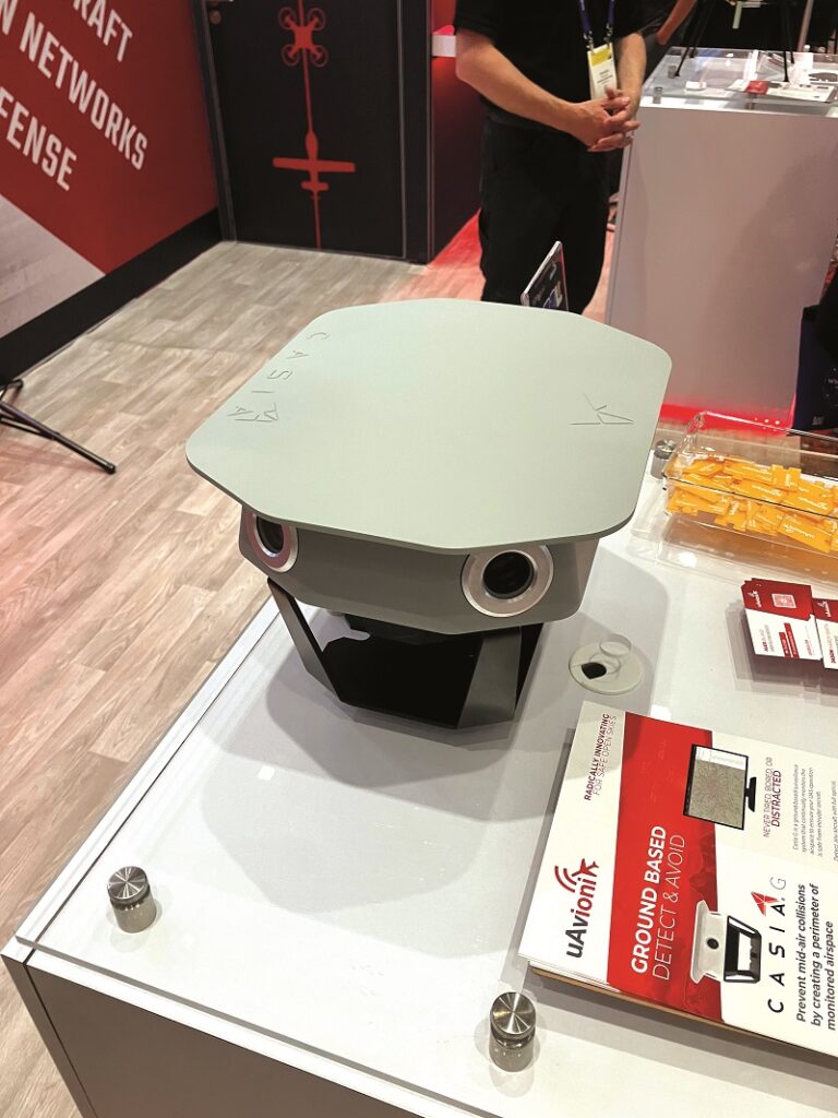
Casia G is a ground detect-and-avoid (DAA) system for monitoring non-cooperative and cooperative air traffic. With an optical view through 360°, it is designed to detect and track anything airborne approaching a UAV operating area, as Jason Hardy-Smith explained to us:
“It streams high-resolution video to a processor that uses AI software to classify small planes, helicopters, drones, birds, etc, and give you their 3D position in real time.
“It also has a dual-band Automatic Dependent Surveillance-Broadcast (ADS-B) receiver built in.”
The company also displayed muLTELinks, which receives command and control feeds through LTE cellular, industrial, scientific and medical (ISM) band, C-band radio links.
“Our muLTEink transmits and receives on all available links to give you path diversity,” Hardy-Smith said. “If you can’t get a signal from your C-band radio on the ground, then maybe you can see an LTE tower. Using multiple modalities also gives you frequency diversity. Lost links are no longer a problem.”
Thirdly, uAvionix highlighted ping200XR TSO, a 100 g ADS-B receiver, configurable in real time through an app. The FAA technical service order (TSO) was granted in August.
“With the ping200XR TSO, you can be compliant globally, and be seen by traffic collision avoidance systems (TCAS), secondary surveillance radar (SSR) and ADS-B receivers,” added Hardy-Smith.
Voliro exhibited Voliro T, a tilting propeller tricopter, designed to transform non-destructive testing (NDT) by enabling UAV-based contact inspections in industries such as oil and gas.
As Shawn Gibbs explained to us at Voliro’s stand, Voliro T was designed for tasks requiring physical contact with structures, such as measuring wall thickness on tanks, pipes and flares.
With its propeller guards and a contact probe, the UAV “touches the wall and tells you the material thickness”, which helps detect potential corrosion without the need for costly scaffolding. With a different contact probe, Voliro T can be used to measure the resistance of the lightning protection system in wind turbines.
Voliro T’s ability to perform inspections in any orientation is key. “You can fly 90o up or 90o down,” Gibbs noted.
Its unique configuration places two protected counter-rotating propellers on each end of a rotating shaft that passes through the vehicle’s fuselage, and a tail rotor that provides control in pitch.
Recent upgrades include extended flight time – now up to 12 minutes with new battery technology – and more durable contact probes.
Gibbs emphasises that Voliro’s subscription model offers full support and training, and the replacement of damaged equipment.
UPCOMING EVENTS


