


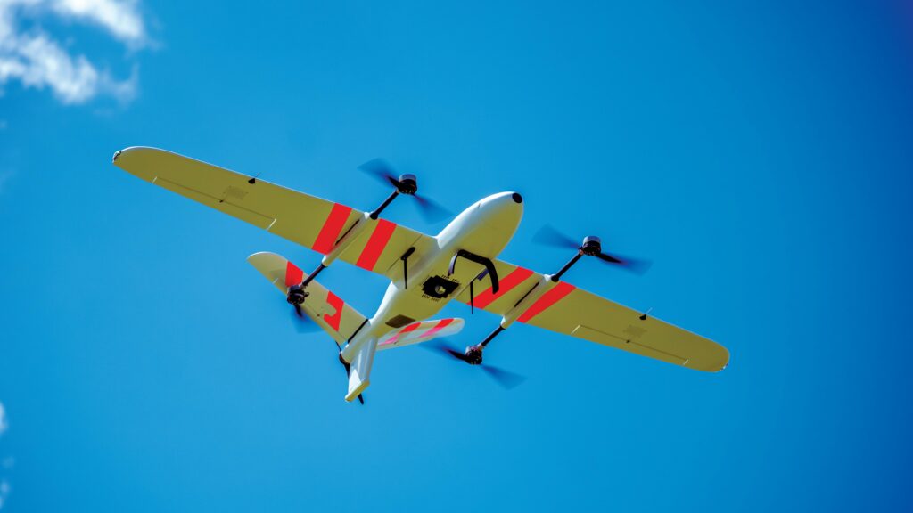
Censys Technologies Sentaero 6 UAS
(All images: Censys)
Sensing essentials
Rory Jackson investigates the wide range of safety-critical engineering and innovation behind this fixed-wing UAV, which is successfully flying asset inspection missions, not only beyond visual line of sight but even over populated areas
Although the general public may occasionally lack awareness of how ubiquitous UAVs may become in the future, those in the industry understand how dramatically autonomous aerial surveillance is changing the game of asset intelligence – that is, condition monitoring, maintenance and optimisations of roads, power grids, waterways, real estate and other infrastructure central to everyday life.
Censys Technologies was founded in 2017 with asset intelligence very much in mind, its team having taken note of how drones could, theoretically, bring down the cost and drive up the value of inspecting assets all over the US and beyond. In particular, its CEO and co-founder Trevor Perrott, who had been a systems engineer working on defence UAVs, became convinced of the need for a middle ground between the somewhat consumer-grade DJI ecosystem and military-grade suppliers like Lockheed Martin, who comprised most of the industry at the time.
“So, John [Lobdell, Censys CTO and fellow co-founder] and I decided to use our engineering know-how to solve that hardware gap and pursue commercial BVLOS [beyond visual line of sight], which birthed the entire Sentaero line thereafter,” Perrott recounts.
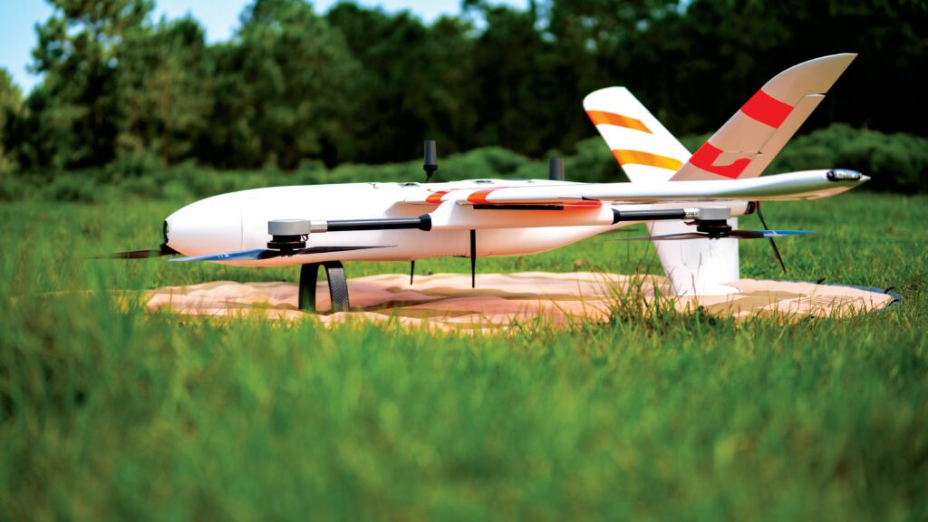
Today, the Sentaero UAV is in its sixth generation, and is thus named the Sentaero 6. It is a fixed-wing, fully electric UAV, designed for VTOL-transitioning through its twin boom-mounted quad lift rotors, and capable of up to two hours’ flight endurance or 90 mi (144.8 km) flight range, with its communications range limited only by cellular connectivity.
A pusher motor-prop at its tail drives its 45 mph (72.4 kph) cruise, with its airframe and flight control surfaces (distributed across the two wings and a Y-tail) enabling tolerance of up to 20 mph (32.2 kph) winds and 30 mph (48.3 kph) gusts.
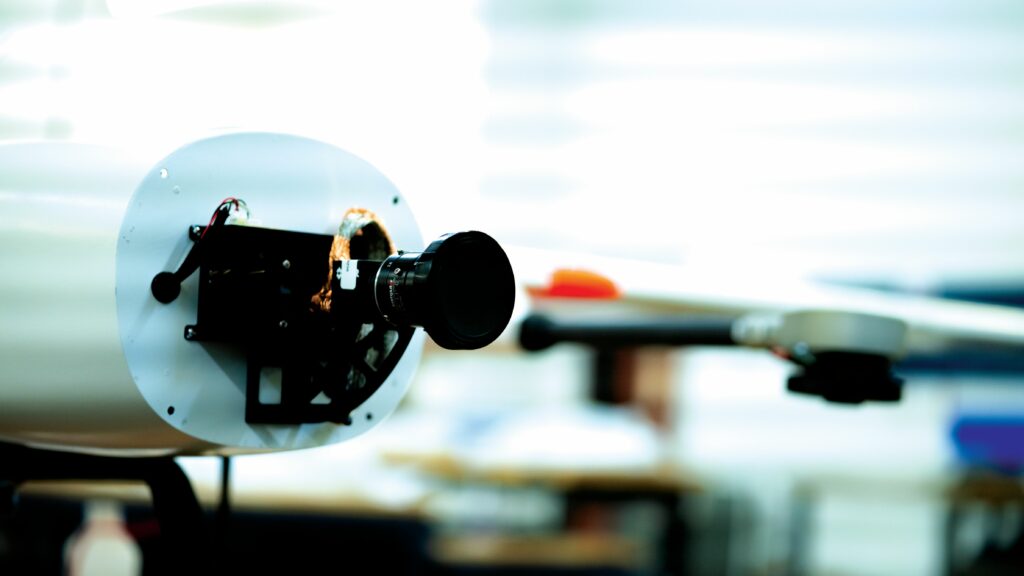
The Sentaero 6 operates on an MTOW of 42 lb (19.1 kg), its empty weight being 36 lb (16.3 kg); the difference, naturally, forms the craft’s payload capacity, which is distributed between its dual payload bay. This is a single payload bay that can house multiple sensors in a single payload box, including (as of writing) Sony’s ILX-LR1 camera, GeoCue’s TV540 airborne Lidar, NextVision’s Raptor 360 Gimbal, the Sentera 6X, the Mapper+ Lidar from Yellowscan and the Phase One P5 camera.
In addition to that UAV, now matured and designed-for-manufacture after nine years of trials and iterations, the overall system offered by Censys includes key software and (optional but valuable to particular customers) ground infrastructure tools.

The former encompasses Censys’ CensOps software for mission planning, scheduling and fleet management, and its analytics solution CensWise for processing Sentaero’s collected data into actionable intelligence reports.
The ground infrastructure elements include both GCS and resident dock systems; these and Censys’ software solutions will be examined henceforth, to unpack in comprehensive terms, why Censys exists as a company and how this uncrewed aerial intelligence solution is successfully surveying power lines, rivers, wildfires, hurricanes and much more across North America.
Development timeline
In the pursuit of maximising value for its customers, Censys’ engineering and certification of Sentaero 6 have prioritised safety and compliance for flying BVLOS, to enable data gathering on a larger scale than most UAVs to date – alongside more traditional design targets such as minimising operational costs and equipment-related overheads relative to conventional UAVs or crewed aircraft.
The cost-optimisation aspect is clear through the changing configurations that Sentaero went through from its earliest versions – which were hand-launched – to its modern-day, VTOL-transitioning descendants; in no timeline did Sentaero ever rely on burdensome external infrastructure such as catapults, nets or runways.
“Sentaero 1 was something of a closer-range drone than any that followed after its introduction in 2017, while Sentaero 2 was capable of three hours’ flight endurance, but both of those were hand-launched,” Lobdell recounts.
“We realised through trials – like using Sentaero 2 in storm response BVLOS, and again in a hurricane response in North Carolina – that there are serious challenges in working in real-world, high-stakes environments with hand-launched systems. Trying to find suitable areas where we could launch or land was really difficult.”
Hence, Sentaero 3 came in 2019 with VTOL, unlocking greater versatility in the environments from which the UAV could launch or land. Sentaero 4 followed in 2020, integrating key detect-and-avoid systems to better facilitate BVLOS approvals and flights of significantly increased length and greater range and in more complex airspace.
“Sentaero 5 had completely the same airframe as the 4, but was entirely different internally – by the time we released the 5 in 2022, we’d upgraded to an enterprise-grade autopilot, and introduced much more robust avionics, including onboard processing for payload support, a better GCS and an LTE C2 data link for over-the-horizon connectivity,” Lobdell continues. “Our previous SDR system only gave us a few miles of BVLOS communication, but with LTE, we can fly as far as the battery allows.
“These might sound costly, but adding reliability shaves away years and years of aircraft or subsystem replacement costs in the long run.”
Thus, upon its introduction in Q1 2025, Sentaero 6 brought customers a plethora of improvements based on Censys’ eight years of testing and project experience. Among these were new power distribution and redundancy architectures, several enterprise- and automotive-grade low-level components to enhance reliability and the most robust safety parachute solution the company had found to date.
“We’d originally used a parachute in Sentaero 2, but dropped it in subsequent generations because we’d found the technology wasn’t quite ready or reliable enough for our standards,” Lobdell says.
“We also introduced CAN-based servos, airspeed sensors and electric motors, giving us full telemetry feedback so we can actually monitor all of those subsystems in real time for health, performance and any possible issues. We also added safety lights across the airframe for visibility to operators and air traffic.”
Additionally, in the interest of value maximisation, the Sentaero 6 came with the aforementioned dual payload bay design, thus increasing the density and variety of data that can be gathered per flight. It additionally received a battery upgrade to enable its two hour endurance, boosting its flight and data collection uptime.
“Integrating all of these new things doesn’t just mean collecting more data at a larger scale; it means we can fly over urban areas,” Lobdell notes.

“For Sentaero 3, we had to apply to the FAA for flight permissions within very specific geographies, usually low-risk jobs over rural environments, maybe power transmission lines at a stretch. But by the time – and functional safety – of Sentaero 5, we could get approvals for our operators anywhere in the US, meeting certain criteria, up to and including surveys over New Jersey’s railways next to the suburbs. And with Sentaero 6, we can fly safely over those suburbs.”
The road to 108
Being approved to operate with as much freedom as crewed aviation takes compliance with not only the latest UAV-specific regulations, but also with (correctly anticipated) future regulations.
While the proposed guidelines for Part 108 on BVLOS UAS were published in August 2025, Censys has taken care to evolve its operating standards, safety improvements and engineering targets in a way that ensured Sentaero’s future capacity to integrate into the US’s national airspace since its inception.
While most of Censys’ flight hours were performed through Part 107 waivers, the company is now working through the FAA 44807 process, which – in addition to enabling exemptions to Part 107’s limitations – functions as an effective pathway towards compliance with Part 108.
“If you want to operate BVLOS, or over people, or with more than 55 lbs MTOW, Part 107’s limits are very restrictive and require you to build up a safety case detailing all technical and operational history info about your UAS,” Lobdell says.
“But for 44807, what you need is a full system safety analysis of your aircraft, identifying all failure modes, redundancies and so on at the component level, with robust flight test data and software controls.
“It’s a big leap for some, but for us it’s really just meant reformatting and repackaging what we’re already doing across our engineering and documentation practices, and we’re excited about codifying the sort of autonomous, remote one-to-many operations that we’re targeting and that are targeted by Part 108.”
Perrott adds, “It’s been really helpful that we’ve been maturing our tech for nearly a decade now, carrying over technical progress from one Sentaero generation to the next, as in the regulator’s eyes, we’re not starting from zero. Without that organisational track record, other organisations can be left climbing a very steep hill to prove that their UAS components work well together in a way that’s safe and reliable.”
Flight and power safety
The flight controller is arguably the most safety-critical component of any UAV, given its role as the central brain for intelligent navigation, control and many other airworthiness qualities. In seeking optimal airworthiness and long life for Sentaero, Censys adopted the Auterion Skynode with the aircraft’s fifth-generation release in 2022, being a well-established, compact, high-power and NDAA-compliant autonomy platform.
“We also use Auterion’s AI Node for onboard data processing, so that we’re really processing at the edge, in real time, to detect things of interest for any kind of end-user’s assets and needs,” Lobdell adds.
While a robust flight computer ensures a capable and reliable brain for flight missions, reliability in aircraft also depends on well-engineered flight control networks and surfaces, these forming much of the changes between Sentaero 5 and 6.

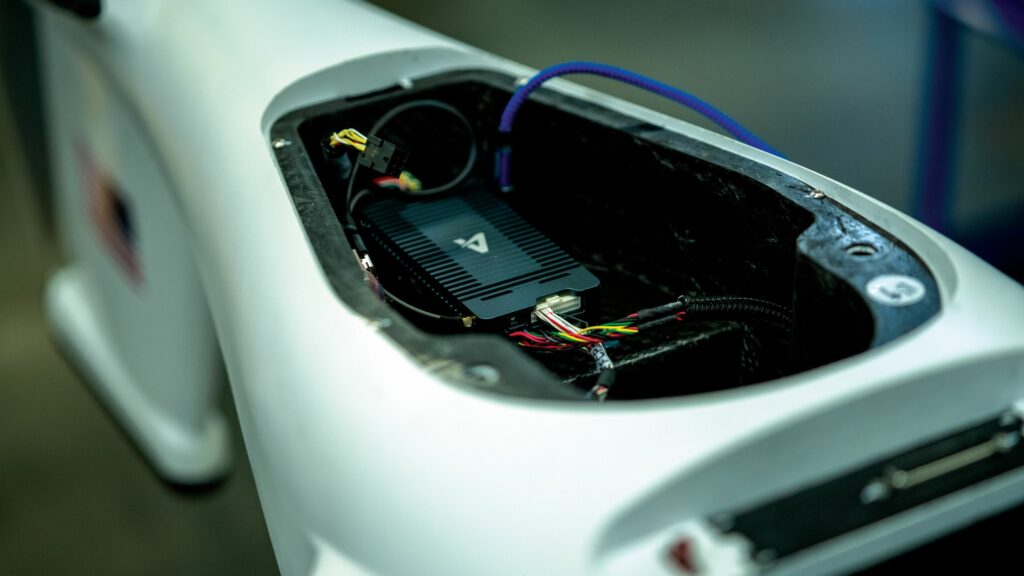
“We built Sentaero 6’s power distribution boards in-house, with automotive-grade components, to ensure fully redundant power to our autopilot, segregating different critical sub-components so that they’re on different power rails,” Lobdell explains.
“If one rail fails, the other should continue functioning independently; moreover, its control actuators are on a different rail to the VTOL lift motors, so power always runs to at least one of our two means of controlled flight unless there’s a total battery failure – and if that happens, that’s when we fall back on that parachute I mentioned, but we do consider use of the parachute to be an engineering failure. We never want customers to reach that level of critical failure.”
As a final boost to safety, Censys opts for Hitec Commercial Servos as its source for flight actuators, not only for the established quality and consistency with which the South Korean manufacturer supplies that particularly cycled and stressed component worldwide, but also for its newer generations that function with DroneCAN.
Via DroneCAN, the flight controller, ground operators and maintenance technicians can amass and analyse telemetry on the servos’ condition, lifespan and so on. Censys sets its servo maintenance cycles based on Hitec’s recommendations to further minimise the incidence of faults, and has tested samples of Hitec’s products for thousands of hours in-house to validate their performance and longevity.
Chutes on chutes
Additionally, if an imminent failure mode particular to forward flight is detected, such as approaching stall conditions or a geofence breach, the UAV can autonomously start ‘quadchuting’, in which its four electric motors spool up to a speed and power beyond the slow, steady state typical to takeoff and transitioning.
“In quadchuting, we want to get into a hover as instantaneously as possible, almost as if it were a midair emergency stop,” Lobdell says. “As standard, it’ll either keep hovering or return to launch location [RTL], and we document our recommended protocols, but the operator can choose their preferred response.

“They can land in-place, although we don’t recommend that unless they know with certainty that they’re flying over safe ground for landing – or they can re-transition back into forward flight if the issue’s determined to have not come from anything safety-critical.”
On top of ensuring sufficiently reliable e-motors for serving as such a back-up (as well as powering and controlling all VTOL phases efficiently and with long life for maintenance purposes), Censys needed an NDAA-compliant supplier – a rarity throughout the heavily Chinese-dominated industry.
“Ultimately, we went with Vertiq. Not only were we impressed with their support, but their motors are some of the most efficient we’ve ever tested,” Lobdell says.
“They’re also very reliable – Vertiq claims a 2000 hour lifespan, and from the CAN data we’ve collected from their motors so far, we expect to cleanly hit that. Their products come with good features too; for instance, packaging the ESC inside the motor definitely helps with our form factor optimisation. And parking the motor – so that the propellers don’t create excess drag – adds maybe 10 full minutes of extra flight time per mission.”
Regarding propellers: the Sentaero 5 featured frontal tiltrotors, but these were discarded because Perrott, Lobdell and their engineers chose to optimise propeller aero towards lift (as trying to have a prop efficiently handle both drove irritating efficiency losses across virtually every phase of flight). Hence, the quad-aeroplane hybrid approach enabled them to stick with a low blade pitch angle optimal for efficient VTOL and hover.
Smart avionics
With airspace safety authorities (such as EASA in the EU) increasingly requiring that UAVs integrate a frontal camera-based situational awareness capability, the Sentaero 6 has incorporated a Casia solution from uAvionix (following its acquisition of Iris Automation), which uses computer vision and AI analytics to detect and avoid crewed aircraft such as small planes and helicopters.
“We also use uAvionix’s ADS-B In receiver, and we had integrated their ADS-B Out a long time ago for a specific client, although it’s been deemed not legal for UAVs like ours to use them anymore,” Lobdell says.
As mentioned, an RTL function can engage following a fault mid-flight, including if communications should be lost for too long (as users, mission requirements or regulators may variably determine). Typically, that means the UAV reversing course to return along the flight path taken thus far – as most Censys customers fly corridor missions such as river, road or power line surveys – to ensure the aircraft stays out of forbidden airspace on its way back to the launch site or a checkpoint.
This will vary as appropriate; for instance, in wide-area mapping with zig-zagged paths over squares of farmland, the UAV can fly a straightened line back to its launch point, its operator knowing full well that they have airspace clearance.
In pursuit of highly reliable navigation, such that the UAV cannot easily be jammed and then spoofed off-course by hostile actors, Censys chooses a GNSS receiver from ARK Electronics based on the triple-band Mosaic-X5 GNSS chipset from Septentrio. Additional GNSS fail-safes are maintained, however, and their behaviour and reliability have been validated through both simulations and real-world flight.
“For example, with how the Auterion Skynode functions, if you do get a GNSS drop-out, it’s generally for no more than a couple of seconds,” Lobdell says. “The GNSS then gets rebooted, so that it’s back online before anybody notices or cares, and within that interim, the IMU drift is immeasurably small, so the inertial data is more than enough to cover the drop-out.

“If we get total loss of GNSS, we’ll fly on inertial readings for about a minute, and if we pass that we’ll trigger a controlled landing. It’s very, very unlikely that that would ever happen, but that’s the order of the fail-safes we’ve engineered.”
In general, however, navigation loss is less likely than comms loss (as many reading will know firsthand). To minimise the latter, Censys integrates the Elsight Halo as its C2 device of choice, which incorporates cellular and proprietary network connectivity along with various smart encryption and channel-hopping capabilities.
“It’s also highly redundant, including combining four redundant LTE modems on different carriers,” Lobdell says. “And on top of that, we have a Doodle Labs radio, which provides a direct SDR link as well as close-range operational connectivity, and is managed by the Elsight radio as a kind of fifth redundant system.”
IP54
Although the safety measures mentioned thus far have gone deep into the components and software-defined behaviours of Sentaero 6, mention must be made of its first, outermost safety layer: the airframe, which Censys has toiled to design to IP54 (protection against limited ingress of dust and splashes of water from any direction). While some testing remains to validate that rating, several architectural choices are key to its anticipated success.
“For example, Vertiq has an IP rating kit that helps us integrate the e-motors and their internal ESCs in line with IP54, which would otherwise pose major points of ingress,” Lobdell says.
“And to prevent the thermal management system creating ingress points, we switched away from the previous Sentaeros’ external vents for the active cooling fans, instead using a mixture of internal fans and externally exposed heat sinks with Sentaero 6 to give it a sealed body.”
The seals and gaskets across the UAV are to be designed as part of Censys’ IP rating program around the end of 2026. The payload poses the most challenging section to bring to IP54 compliance, particularly since Censys uses specialist suppliers’ payloads, and such companies generally do not design to high IP ratings or provide custom versions at budget-friendly prices.
It is also inherently challenging to build an IP-rated payload gimbal or housing because lenses must typically be left at least somewhat exposed or open to ensure visibility. Censys has, however, designed Sentaero 6’s payload bays with extra room for integrating a larger connector in future that will bear an appropriate IP rating (either meeting or exceeding IP54), and it remains open to payload options with strong IP ratings.
Ground infrastructure
On top of providing a Lenovo Legion Go 2 tablet as a cost-efficient, standard-issue GCS, Censys has assembled and delivered a variety of its Sentourion mobile command centres.
These can be built into a range of commercially available vans, trucks or trailers, incorporating computers, radios, health and safety equipment, climate control systems and power solutions including solar panels as requested.
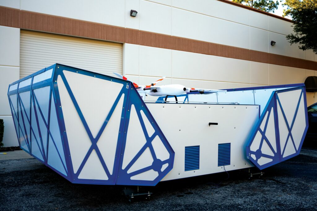
Moving forwards, however, the company’s next big paradigm shift revolves around its resident docking and charging station, EdgeDock, to be released in June 2026.
“EdgeDock will enable Sentaero 6 a 2800 square mile service radius, with CensOps initially empowering one operator to manage up to five UAVs and their missions at a time via their EdgeDocks, and the upcoming Part 108 regulations strongly support that kind of industrial-grade, one-to-many CONOPS,” Lobdell says.
The aforementioned resident version of Sentaero 6 will recharge conductively via its landing struts and EdgeDock’s landing platform. It will also integrate EO and IR nadir cameras to help facilitate precise, vision-based (and all-weather, all-visibility) landing on the platform, as well as some localisation relative to its position.
Censys anticipates autonomy handling most of the active surveying work on behalf of the customer, and has endeavoured to make EdgeDock as comprehensive a solution as possible for handling all ground work and telecoms relating to the UAVs’ condition and amassed data.
As Perrott tells us, “EdgeDocks will bear installing essentially wherever you’d put a cellular tower, and wherever you need more data, you’d put down more EdgeDocks and more drones.
“Continuous mapping of all of North America, with centimetre-accuracy, sounds like a big dream to achieve – but it would virtually eliminate countless scourges, including all the power line-ignited wildfires that keep happening and hurricane insurance fraud – property insurance fraud is rampant all over the continent, but constantly goes unnoticed because people don’t have good enough maps.”
The company also hopes to decentralise cloud processing by equipping each EdgeDock to function as a miniature data centre. Hence, each unit incorporates wireless connectivity for data offloading, as well as full HVAC climate control, weather sealing, redundant power, wireless charging and smart remote battery management. These are housed within a self-contained unit designed for no more maintenance than at quarterly intervals (with annual inspections likely being sufficient in most environments).
“Moving the data to a generic, AWS-type cloud solution can get really expensive, so data movement is actually a tougher challenge than data processing,” Lobdell notes. “So, to try and minimise data movement, we preprocess it onboard the dock after the UAV remotely offloads it, and then what we end up delivering to customers is effectively just a dashboard of key, relevant, actionable information.
“For instance, we do a lot of vegetation encroachment surveys for utilities; for those, the aircraft lands, the data are offloaded and preprocessed on the dock into the right file types like a .KML, and some hours later we’ll have converted a 100 GB file into maybe a 1 GB dashboard showing detected encroachments in map snippets. And the more of that work we can do at the EdgeDock, the further we can reduce the costs and complexities of getting customers the answers they need.”
Software essentials
CensOps principally functions by users uploading .KMLs of their property or infrastructure, and selecting which assets they want Sentaero 6 to fly over. Mission planning and safety checks are then heavily automated via APIs, to reduce both human error and mission planning times. Censys notes that cutting-edge BVLOS surveys today take five to 10 hours of planning per singular hour of flight depending on mission area and complexity (with five hours being an industry-leading tier of planning efficiency), and expresses its wish to reverse that ratio entirely.

In addition to its mission planning and ‘remote autonomy management’ functionalities, CensOps also integrates all fleet management necessities, including all data to be logged through EdgeDock on UAVs’ flight hours, motor usage, battery cycles and other information critical to maintenance and worthy of analytics for efficient fleet care.
“We developed CensOps mostly because all the COTS solutions we looked at were either too broad or too specific to match what we and our users needed, either in terms of gearing up for Part 108, or having one too many unnecessary features that could pose a mission hazard,” Lobdell says.
“And for working in safety-critical environments, we really need to be able to adapt via new features and fixes of our own. Having our own combined GCS and fleet management portal in CensOps means we can very nicely tie those together, and forward them smoothly into CensWise, which will grow increasingly adept at predicting infrastructural maintenance needs across the US as EdgeDocks become more widespread.”
Future
As Censys continues to manufacture Sentaero 6 in batch quantities, remaining engineering adaptations are limited to the minor hardware changes already mentioned for its resident variant, as well as potential software-based features to come, such as a terrain-following capability in the works.
“But the bulk of adaptations will be market- and customer-specific; for the immediate future, those will be dominated by the needs of our end users here in the US, especially electric utility companies and DoT organisations – partially because 75% of power lines here in the US are near a road – and real estate will come as a natural next entry point,” Perrott says.
Further down the road, Censys anticipates that expanding into European markets and elsewhere around the world will be greatly aided by two distinct factors: one will be Part 108 coming into effect, and the other will be a convergence of satellite data and UAV data into a common industry and operating picture.
As Perrott concludes, “It’s hard to say how exactly we’ll get from here to there, and it’s bound to take a lot of work and conferences, but I do think that reaching a place where remote sensing is easily planned and carried out – at whatever scale or resolution the customer wants – is the future that all of this has to be marching towards.”
Key specifications
Sentaero 6
Fixed-wing UAV
Fully electric
Fixed quad lift motors
Pusher propeller
Dual payload bay
MTOW: 19.1 kg
Payload capacity: 2.7 kg
Operating airspeed: 72.4 kph
Maximum endurance: 2 hrs
Maximum flight range: 144.8 km
Maximum wind tolerance: 32.2 kph
Maximum gust tolerance: 48.3 kph
Some key suppliers
Flight controllers: Auterion
Servos: Hitec
C2 systems: Elsight
Radios: Doodle Labs
GNSS: ARK Electronics
GNSS chipsets: Septentrio
Detect & avoid systems: uAvionix
Electric motors & ESCs: Vertiq
Parachutes: Drone Rescue Systems
GCS: Lenovo
EO/IR: NextVision
Geospatial cameras: Sony
Geospatial cameras: Phase One
Multispectral cameras: Sentera
Lidars: Yellowscan
Lidars: GeoCue
UPCOMING EVENTS

