


Data / connections
(Image: UAV Navigation)
Double trouble
Ensuring reliable communication for UAS is demanding technological advances in many fields, explains Nick Flaherty
Resilience in data communications is a key consideration for uncrewed systems, whether in the air, on the ground or in the water. Assurance of that resilience can be provided in a number of ways, from redundancy to mesh topologies to satellite and millimetre-wave links. Emerging technologies from 6G to IEEE 802.11bn (also known as Wi-Fi 8) are addressing resilience and latency requirements as well as providing more bandwidth, with chips and modules currently undergoing tests.
LPD connectivity
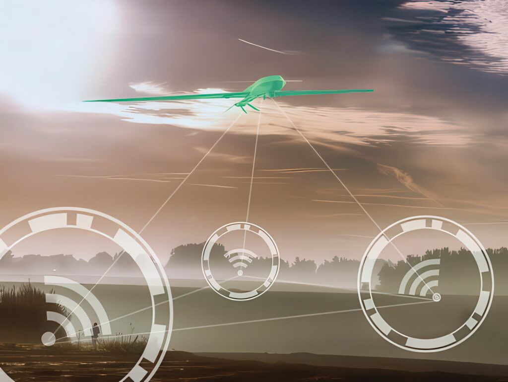
Uncrewed aerial vehicles (UAVs) are increasingly vital to the defence and security industry, as seen in the Russian–Ukraine conflict. UAVs enable low-cost reconnaissance and can be deployed in fleets for offensive operations.
Ensuring constant connectivity to relay data from these UAVs is vital, but connectivity can also create the potential for detection by adversaries. Reports indicate that Ukraine has been losing up to 10,000 UAVs a month from Russian forces detecting and destroying them.
(Source: Blu Wireless Technology)
Every signal transmitted is a potential liability. In environments saturated with electronic warfare (EW), even milliseconds of visibility can lead to intercept, triangulation or direct targeting. Therefore, tactical communications must now minimise exposure, not just encrypt data.
(Image: Blu Wireless Technology)
While 5G cellular networks have brought new capabilities to military UAV connectivity with higher bandwidth and lower latency than 4G LTE, there are significant challenges. 3GPP 5G technology is unsuited to UAVs because it requires subscriptions to a network operator and supporting infrastructure such as mobile towers.
Using traditional wi-fi may enable UAVs to hide in plain sight owing to the sheer number of connected devices, but the omnidirectional, short-range signal is easily interfered with and detected, making it a risk in a battlefield environment. 3GPP 5G mobile networks encounter similar interference and detection issues but command longer range than beyond line of sight thanks to their use of tall mobile towers and lower frequencies.
There are also private 5G networks that may be more suitable for UAV connectivity because they use a dedicated slice of the spectrum, enable direct connection and provide low latency. However, use of the spectrum is tightly regulated and there isn’t much clarity around how the spectrum should be shared between commercial and military users.
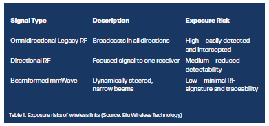
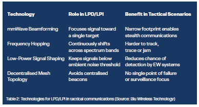
Low Probability of Detection (LPD) and Low Probability of Intercept (LPI) are techniques used in tactical communications to reduce the visibility and vulnerability of signals on the battlefield.
LPD is designed to minimise the chance that an adversary can even detect the presence of a signal. This is achieved through measures such as directional transmission with beam-forming antennas, low-power emissions and noise-like waveforms that blend into the electromagnetic background.
LPI makes it difficult for an adversary to intercept and exploit a signal, even if it is detected. LPI often involves beamforming, frequency hopping and spread-spectrum modulation to prevent capture or decoding.
LPD and LPI are distinct from encryption. Encryption protects the content of a message, while LPD and LPI protect the signal itself – including its presence, direction and vulnerability to tracking.
This is where LPD/LPI capabilities matter. Systems built with directional transmission, beamforming, signal power control and frequency agility offer significant operational advantages. They reduce the RF footprint, dodge intercept tools and resist jamming, all without sacrificing data throughput.
Special operations teams relying on real-time intelligence in enemy territory need to stay electronically invisible. LPD mesh links allow them to send and receive data without giving away position. In forests or urban canyons, traditional radios scatter signals, but LPI-focused directional links ensure that vehicles maintain line-of-sight connectivity without broadcasting widely.
UAVs and uncrewed systems on the ground operating without central control must communicate without attracting attention. Beamformed, self-routing signals enable coordination while remaining hard to jam or detect. Robotic units in a swarm coordinate in real time using LPI-enabled directional links, avoiding jamming and minimising RF exposure while on the move.
LPD and LPI are the result of a converged architecture. Multiple technologies work in tandem to reduce signal visibility, minimise intercept risk and maintain operational control under pressure.
(Source: Blu Wireless Technology)
Used together, these technologies create position-independent, resilient and low-signature networks – a far cry from legacy VHF/UHF systems with persistent, trackable emissions.
For example, mmWave mesh networks layer these technologies into a single operational model. Units can dynamically connect, adapt routes and maintain encrypted links, all without triggering standard electronic surveillance systems.
Passive EW systems simply listen for transmissions, whereas LPD systems avoid triggering these by using ultra-low-power signals and beamformed links that don’t scatter energy into the environment. Active EW systems attempt to disrupt or trace communications. LPI methods like frequency hopping and encrypted mesh routing make this difficult, if not operationally unviable.
(Source: Blu Wireless Technology)
LPD and LPI techniques address the risks of detection, interception and jamming by reducing RF signatures, shaping transmissions and making signals harder to exploit. The communications systems need to integrate beamforming, frequency agility, low-power signalling and mesh networking to deliver measurable stealth performance.
Mesh networks
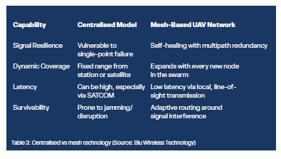
Traditional UAV communications rely heavily on centralised models, either through ground control stations or satellite uplinks. These systems work well under ideal conditions but break down quickly where communications are denied and signal stability is compromised.
Tactical mesh networking offers a fundamentally different approach.
Instead of routing all data through a single point, mesh networks allow each UAV to act as both a node and a relay. This node-to-node routing creates a self-healing, decentralised web of connectivity across all airborne assets in the area of operations.
In tactical scenarios, such as swarm reconnaissance or maritime UAV launches, UAV mesh networks enable continuous coordination, even when external infrastructure is unavailable or under threat.
For example, a UAV swarm in an urban canyon environment using mesh links with mmWave between 25 and 100 GHz can maintain high-speed comms without GPS or satellite fallback. As long as line of sight exists between at least two nodes, the mission continues autonomously and undetected. A self-organised swarm can maintain high-resolution video streams back to a mobile command vehicle without satellite links and provide continuous surveillance without RF signature spikes.
Protocol
One way to provide more resilience is the protocol. The Multiple Access with Collision Avoidance for Ad-Hoc Networks (MACA2) protocol is an evolution of the original MACA protocol, designed specifically to resolve Hidden Terminal and Exposed Terminal problems in wireless networks, such as those used by UAV swarms or autonomous vehicle platoons.
MACA2 uses a slotted handshake mechanism to ‘reserve’ the airwaves before sending data in a four-way handshake. This uses a specific sequence of control packets to ensure the path is clear.
The sender (for instance, a lead UAV) broadcasts a request to send (RTS). This packet contains the duration of the intended data transmission.
The receiver responds with a clear to send (CTS). Any other devices overhearing this CTS now know to remain silent for the specified duration. The sender transmits the actual data packet and the receiver confirms successful delivery.
(Image: 8devices)
This allows more reliable connectivity in a swarm, avoiding a collision. MACA2 adds various enhancements, such as Slotted Aloha Timing. This synchronises transmissions into time slots to reduce the probability of RTS packets colliding with each other. Packet bursting allows a device to send multiple data packets after a single RTS/CTS cycle, which significantly increases efficiency for high-bandwidth tasks like 4K video streaming from a drone. Adaptive backoff is used so that if a collision does occur, the initial UAV waits a random, mathematically optimised amount of time before retrying, preventing the network from ‘clogging’ under heavy load.
Preloaded firmware and optimised hardware deliver connectivity ranges of up to 80 km. Key features include narrow channels, expanded frequency ranges, as well as frequency hopping and interference mitigation.
Positioning
A radio link can also be used to provide positioning data for UAVs when the satellite navigation system has been blocked to provide more resilience.
A system called Kepler Advance converts the incoming Remotely Piloted Aircraft Systems (RPAS) signals from the ground control system to outgoing signals.
These responses are processed at the ground station and determined with an accuracy similar to the accuracy provided by satellite systems to provide the distance of the RPAS from the ground station, the angle of the RPAS relative both to the ground station and to North, and the height above ground of the RPAS.
With these three data points, the spatial position is determined in a data format similar to that provided by GNSS systems and delivered to the ground station.
These data can be used as a true reference for navigation, mission execution, representation on an interactive map, etc and as a reliable and robust substitute for GNSS systems.
The radio system provides a resolution that improves the usual GNSS by 40% and is difficult to block because it uses LPI technology and the working frequency is not known. This means it is highly unlikely to be subject to spoofing because it is neither public nor widely known hardware or software, and it works in any terrain (water, desert, etc) regardless of weather conditions.
The system also does not accumulate errors, meaning that the level of the accuracy remains constant.
The Kepler Advance system has been tested on a 150 kg Class 1 UAV without any satellite navigation, and directly compared with a UAV using GNSS for three hours. All of the trials were successful.
Satellite links
Various forms of satellite technology are becoming increasingly viable options as alternative links for uncrewed systems in the air and on the ground. The latest version of the 5G specification, Release 19 of the 3GPP specification for new radio (NR) non-terrestrial networks (NTNs), provides a standard for routing 5G signals over satellite links to cellular phones. With satellites in low earth orbit (LEO), this provides higher bandwidth links with smaller, lighter antennas than possible previously and allows integration into smaller UAV platforms.
The latest LEO broadband NR-NTN trials with full duplex links can provide 5G links, including NTN satellite and mmWave, to both UAVs and driverless vehicles.
Sub-Band Full Duplex, which is a key physical layer technology applicable to 5G-Advanced and 6G, provides improvements in the unpaired Time Division Duplex spectrum, significantly boosting uplink coverage and reducing latency. Both factors are key enablers of new services. The latest 5G-Advanced modems provide speeds of up to 12 Gbit/s as support for 3GPP-standard Release 17 and Release 18 specifications, simultaneous connectivity for the FR1 sub-7 GHz and FR2 mmWave bands and a novel smart antenna technology that uses AI to identify the type of use and boost data throughput.
The smart antenna uses the quality of the signal to detect the environment around the modem, and to actively tune the antenna and uplink power to ensure that signal quality is maintained.
This has been tested in the Ku band from 12 to 18 GHz with a 50 MHz channel bandwidth using a European LEO constellation with the Rel 19 specification. For real-time NR-NTN channel characterisation, the NTN test suite replicated the Ku-band conditional handover scenarios in the lab.
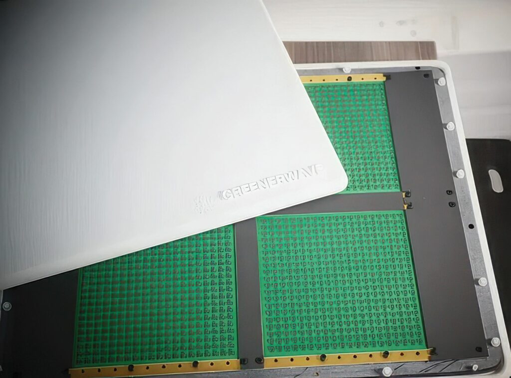
(Image: Greenerwave)
Another smart antenna technology for satellite links combines a Reconfigurable Intelligent Surface (RIS) and physics-based algorithms to efficiently and dynamically direct signal carrier waves in real time to create flat panel antenna systems for satellite links.
The RIS uses standard printed circuit board technology with off-the-shelf components rather than custom ASICs to reduce the dependence of custom silicon and moving configuration into software.
The technology, which is both more efficient and less energy-intensive, also offers the advantage of reducing dependence on semiconductors compared with conventional designs, offering major potential for defence, space, automotive and telecommunication applications.
Ground vehicles
Cellular vehicle-to-everything (C-V2X) has emerged as the dominant technology for datacoms to ground vehicles following the deprecation of the DSRC standard in the US last year. C-V2X relies on the progression of the 3GPP standards with 5G technology being dominant. This provides the latency required for remote driving, which is turning out to be a key element in providing support for autonomous operation. One vehicle operator is using remote drivers and the wireless network to move vehicles at low speeds of up to 2 mph in the event that the autonomous driving stack cannot cope with the situation.
Vehicles already use dual SIMs and dual eSIMs to ensure resilient connectivity to global cellular networks to transfer data. However, there is need for connectivity in locations where a cellular network may not be accessible, for example in black spots or in rural areas. In such circumstances, satellite connectivity is being seen as a viable technology with the latest Rel 17, 18 and 19 specifications.
Demonstrations of satellite connectivity to vehicles have been performed in Europe and the US. A European satellite constellation is planned with a very low earth orbit (vLEO) at 375 km that reduces the latency for connections to vehicles using the 2 GHz band. A US demonstration uses a hybrid modem that swaps from a terrestrial network to NTN via a LEO network.
New technologies
Federal regulators in the US have proposed repurposing the 5.030 to 5.091 GHz band, known as the C-band, for UAV uses. Researchers are looking at how this spectrum band can be used efficiently to provide communication links for reliable data transfer between a UAV and a ground control station that can be protected against interference. The researchers are developing a Dynamic Frequency Management System that coordinates spectrum access in this frequency band.
(Image: Rohde & Schwarz)
There is only around 60 MHz available in the frequency band under consideration by the FCC, so efficient spectrum allocation and usage is very important to support more UAV operators and improve spectrum utilisation. This will require spectrum coexistence algorithms, AI-based spectrum sensing techniques and a decentralised system for reserving bandwidth in advance. This will enable third-party service providers to provide dynamic, time- and location-based spectrum access for UAV operators, creating an effective ‘pay-as-you-fly’ market for time-sensitive deliveries such as medical supplies to remote communities or tribal nations.
(Source: Mediatek)
In addition to developing dynamic spectrum access algorithms, researchers are conducting multi-UAV flight tests to validate the technology. This will flight-test multiple UAVs sending and receiving data, thereby examining the bandwidth and spectrum requirements by collecting measurements under various conditions. The flight tests will involve multiple UAVs flying at the same time for extensive wireless channel measurements in this frequency band, and to assess whether dynamic spectrum policy could meet safety and regulatory requirements.
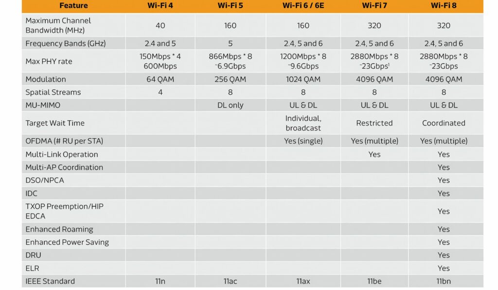
Wi-Fi 8
Several chip designers have produced chips for the new standard so they can be tested. This is particularly important as the IEEE 802.11bn standard represents a fundamental shift in wireless evolution by prioritising Ultra-High Reliability (UHR) over the raw throughput gains that defined previous generations. While Wi-Fi 7 focused on reaching 46 Gbit/s, Wi-Fi 8 is designed to ensure that connections remain stable and provide low latency in the mission-critical environments required for UAVs and driverless cars.
The primary goal of Wi-Fi 8 is to reduce the 95th percentile latency distribution by approximately 25% through several key physical and medium access control layer enhancements.
Multi-AP Coordination allows multiple access points (APs) to coordinate their transmissions using techniques such as Coordinated Beamforming and Coordinated Time-Division Multiple Access (C-TDMA). This prevents collisions and manages interference, which is vital in dense vehicular environments.
Enhanced reliability mechanisms include Distributed Resource Units and a new Modulation and Coding Scheme that increases the codeword length of Low-Density Parity-Check code. These features harden the signal against the rapid fading and interference typical of moving vehicles.
Wi-Fi 8 also seeks to integrate mmWave bands at 60 GHz with legacy sub-7 GHz bands, allowing seamless cross-band coordination.
Autonomous vehicles rely on V2X communication to achieve 360° environmental awareness. In congested urban intersections, Wi-Fi 8’s coordinated spatial reuse allows cars to share the spectrum more efficiently than the ‘chaotic random access’ of older Wi-Fi versions. This ensures that critical safety messages, such as emergency braking alerts, are delivered with sub-millisecond latency despite high network density.
While Wi-Fi 7 introduced Multi-Link Operation to use multiple bands at once, Wi-Fi 8 builds on this with Multi-AP Coordination. This is the ‘brain’ that allows drones and cars to maintain seamless connection as they move through different coverage zones.
This tackles the handover problem when a vehicle moves from the range of one AP (like a roadside unit) to another. In older Wi-Fi versions, this caused a momentary ‘blink’ in data. Wi-Fi 8 uses Coordinated Spatial Reuse, allowing the car to communicate with multiple APs simultaneously without them shouting over each other. This creates a ‘soft handover’ that is invisible to the car’s navigation system.
For autonomous systems in the air, the reliability of a wireless link is a safety requirement rather than a convenience.
Wi-Fi 8’s Extended Long Range (ELR) mechanism improves signal stability for long-distance terminals, ensuring that a UAV remains controllable even as it moves further from its base. The AP Power Save framework is critical for battery-operated UAVs, allowing the onboard radio to switch to a ‘Doze’ or ‘Listen’ state to conserve energy without losing the ability to respond to urgent triggers.
When flying in a swarm, the units are often very close to one another. Under Wi-Fi 7, their signals would cause massive interference. Wi-Fi 8’s C-TDMA schedules the transmissions so that UAVs can talk to a ground station in precise time slots, ensuring that a command sent to one UAV doesn’t drown out the telemetry coming from a neighbour.
Latency is a key requirement in autonomous driving and Wi-Fi 8 is the first standard to specifically target latency outliers to ensure that key commands are delivered within a set time.
Conclusion
Ensuring a reliable, robust wireless connection is a key requirement for an uncrewed system. The evolution of LEO satellite technology is set to provide a second link to vehicles on the ground and in the air using standard 5G modems and antennas, solving the space, weight and power challenges experienced with previous satellite implementations. At the same time, the IEEE 802.11bn Wi-Fi 8 standard currently being tested is set to address the latency issue of the technology and open up another potential connectivity system for uncrewed systems.
Acknowledgements
With thanks to Macy Summers at Blu Wireless Technology and Sebastian Mendez from UAV Navigation.
UPCOMING EVENTS

